|
Newbiggin-on-Lune, Sunbiggin Tarn, Smardalegill Viaduct, Kirkby Stephen, Cumbria. Tue 03 Oct 2006 |
||
|
|
||
|
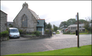
The early drive to Kirkby Stephen was dark and very wet. My planned walk is relatively low so I wasn’t too bothered about the weather. I parked in the town square and put on full waterproofs before walking to the bus stop. I waited for the 7:10am bus which arrived on time and bought a one way ticket (£1.15) on the 564 service to Newbiggin-on-Lune. The price is much cheaper than it would have been in the Chorley area for the same distance. The driver seemed surprised by my destination. “I never make any pick-ups there” he commented. When I arrived the rain had stopped but the sky remained overcast. It was about 7:30 when I set off to follow the old road and cross the very busy A685 to head up the hill towards Crosby Garrett. |
|
|
|
|
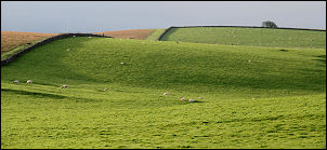
It was very pleasant walking up the unfenced road towards the summit. A large expanse of close cropped grass was on my left and a dry stone boundary wall on my right. I was heading for Sunbiggin Tarn somewhere to the west but I know it wouldn’t be visible from where I was. There was no path shown on the map so I had to make a best guess of a route across the fell. I left the road just north of Gracetemoor and headed due west. The grass was still wet from the earlier rain and before long my socks were feeling a bit damp. There was no path to follow but the going was relatively easy. After leaving the boundary wall behind me I joined a green path which was easy to follow and heading in the right direction. |
|
|
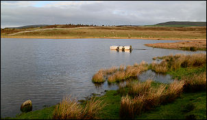
Soon I could see the tarn in the distance and the path was heading for it. I arrived at a point on the map shown as a ford but a fairly new low wooden bridge had been fixed. It all seemed a bit over the top as the land beneath was just a bit boggy. I reached the road and headed NE and alongside the tarn. The last time I was here was 15th May 1980 when I was walking the Cost to Coast path with Charlie. I walked round the north side of the tarn and reached the cabin by the eastern shore, just as we did back then. |
||
|
|
|
|
|
I then headed for Rayseat Pike but could find no sign of a path. The heather was very thick and wet, making the going rather tough. I was glad to reach the road and have some easy walking. I headed right until I reached the wall then left to follow a nice easy path towards Bents. This is now the same path I followed with Charlie while we headed towards the North Sea. I passed Bents and headed up towards Begin Hill, keeping and eye open for the stile through the wall on the right. |
|
|
|
It was well signposted but a sign over the wall said not to go across the field but follow the wall. The reason was to avoid crossing the area of ancient settlements than can be seen by the mounds remaining. As this was one of the main reasons I chose this route I ignored the sign and followed the way suggested by Wainwright in his Coast to Coast book. By now the weather had improved and I chose a nice spot by an ancient field boundary to sit down, have a cup of coffee and take in the view. It was also a good time to take my boots and socks off and wring out as much water from my socks as I could.
|
||
|
|
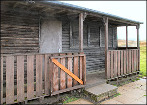
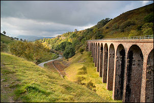
I descended to the old dismantled railway and had a quick look at the boarded up railway building. Descending further I crossed over Smardale Bridge, crossing Scandale Beck. Climbing the other side I got my first distant view of the magnificent Smardalegill viaduct that used to carry the railway. |
|
|
I saw the viaduct for the first time while having my lunch on Knoutberry on Wed 13 Sep 2006. It was way in the distance and I needed my binoculars to see any detail. It was then that the seeds of today’s walk were sown. I followed the old track along the east side of the deepening gorge until I came to the top of the viaduct. It is in an amazing condition and the old rail route is now a footpath. I took a steep line up the east side of the gorge to get a better view. |
||
|
|
|
|
|
I emerged onto a wonderful limestone outcrop called Witches Stride and chose this as a lunch stop. The views were magnificent and even the sun came out briefly. A small stile got me over the fence and I then followed the wall upwards to re-join the Coast to Coast route over Smardale Fell. |
|
|
|
|
|
|
|
|
As I descended to the road near Tom Bank I saw 3 walkers leave the road and walk into the field. I’d seen them earlier, crossing Smardalegill Viaduct, so obviously there is a connecting route to this side of the fell. I joined the road briefly and then across fields to pass under the still working Settle – Carlisle railway then through Greenriggs farmyard and on to Kirkby Stephen and my car parked on the square. | |