|
Lamplugh, Cogra Moss, High pen, Blake Fell, Carling Knott. Cumbria. Thu 1 Mar 2007 |
|
|
|
|
|
It is a lot lighter now and the last part of my drive to Loweswater was in reasonable daylight. The parking place shown on the map was nothing more that a muddy patch of waste ground, but it served the purpose. I set off walking along the minor road along the north side of the lake, heading west towards the coast. I climbed Fang’s Brow then took the left turn towards Lamplugh. I’d driven through some drizzly weather on the way but now the rain seemed to be just holding off. The road was now reasonably flat so I just kept going untill I came to Lamplugh. It’s hardly a village, just a few houses scattered along the lane and a Church. |
|
|
|
|
|
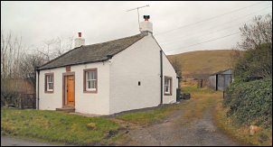
Traditional and modern examples of buildings in Lamplugh. |
|
|
Just before the Church entrance is the path that I needed to take but I though I’d investigate a bit further along the road and returning to take the path later. The Church is St Michael’s, designed by William Butterfield and built in 1870. I didn’t go inside but hope to return in the future. Just south of the church entrance is an interesting gate arch to Lamplugh Hall. All these features need further investigation but I wanted to get on with my walk. |
|
|
|
Back along the lane I took the footpath across the fields to Wrenholme Beck. The path crosses over but there is no bridge. Flood conditions could cause a problem. At Dockray Nook farm the path joins the farm track to Felldyke where I left it for another private track heading for the woods and Cogra Moss reservoir. When I got to the reservoir I was surprised to see its relatively low level. Many small jetties were positioned along the bank for the fishermen. I headed up towards Lamplugh Fell and followed a nice path up the bank to the forest road. There was no obvious path up through the young pine trees towards Low Pen so I just had to battle my way through as best as I could. The battle with the branches didn’t last long and I was soon on open fell. I followed the fence line up to the summit then on towards High Pen. It not possible to see if there is a path marked on the map because of the ridiculously wide purple boundary marker. It is not good mapping practice when the boundaries obliterate underlying detail. There is a superb view back towards Knock Murton which is a low but impressive steeply sided mountain. |
|
The wind was now quite strong so I pressed on to Blake Fell where I knew there was some shelter in a small nook near the summit. It was still overcast but I did have some distant views. I had my sandwiches where I found shelter and continued over the summit before heading steeply down towards Carling Knott. Carling Knott is accessed by a spur from the main range. There is no defined path up to it from the valley and so it is probably not visited very often. But it is definitely worth a visit. The path along it is interesting and varied with great views on both sides. Rocky outcrops abound on the SE side and these provide good shelter from the westerly winds; a perfect spot for a lunch break or just to sit down and admire the spectacular views of Mellbreak and Grasmoor. |
|
|
|
At the northern cairn I turned to the left and down towards Holme Beck. About half way down the fell is a fence which can be followed down at the steepest part of the descent. At the bottom I joined the excellent track to the NW as far as the wooden seat looking across Loweswater. I then descended straight down, through a couple of gates, and joined the main Lowewater shore path which I followed to Hudson Place then the farm track towards the road. |
|
I followed a footpath marker across the fields only to find some wooden boards crossing a boggy patch but the boggy area started before the boards did. Across another couple of fields I reached the road and the short walk back to my car. |
|
|
|
|