|
Stockdale Moor, Sampson's Bratfull, Caw Fell, Haycock, Seatallan. Cumbria. Wed 02 May 2007 |
|
|
|
|
|
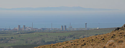
It was a nice sunny drive to the Wastwater area. I’d made good time and arrived at the narrow lane near Nether Wasdale and below Windsor Farm just before 8am. The sky was clear with hardly any wind. I was parked near a cattle grid and each time a car passed by I was nearly deafened by the rattle. I set off up by the river, which doesn’t seem to have a name. The next river to the west does though. A name you couldn’t possibly make up, Turdypack Gill! I met an old stony track and followed between dry stone walls until I came out onto open fell. Keeping the wall to my left I continued round to the left till I crossed a wooden footbridge and a straight lane between tree plantations. On the far horizon was the distinctive profile of Sellafield, which always seems to be there when walking this side of Cumbria. I followed in a dead straight line before turning right and following another straight track towards Brown Edge. The map shows the path running straight down to the River Bleng and up the far bank. Perhaps a right of way exists but no discernable path does. There is no bridge or stepping stones to cross the river so I had to engage in jumping from stone to stone. I was now climbing Stockdale Moor and climbed steadily over rough ground to the pile of stones that the map calls Sampson’s Bratfull and also describes it as a long cairn. |
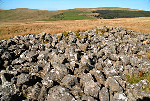 Sampson’s Bratfull long cairn. |
|
|
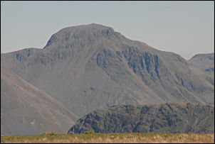
As I headed up the fell in a NE direction I came across a few more much smaller cairns. As the fell steepened the going became easier as I left the tussocky stuff behind. The higher I got the better the views became. I kept looking round to see the Irish Sea and the outline of the Isle of Man on the far horizon. The groove of Red Beck appeared in front so I headed for it and climbed its step left side towards the top of Caw Fell. I found a group of stones and stopped for my lunch in the sunshine. I didn’t go over the top but kept to the 600m contour until I came to the Hanging Stones. They are an interesting outcrop, sticking out into fresh air. |
|
I could see Haycock ahead but wanted to investigate Brown Band on its SW side so decided to miss the summit and head down a little into the head of the valley. It was a very interesting area with small springs issuing from the hillside. I took a refreshing drink from a couple and it was nice top my bottle up with crystal clear and ice cold water. I came across a good path at the Pots of Ashness and followed it up the steep north slope of Seatallan. |
|
|
|
There was only a little wind and I was able to enjoy the views. The last time I was here it was so windy I could hardly stand up. A wonderful easy path descends to the SW and I followed it to the small cairn at Cat Bields. I wandered over to what the map calls the Buck Stone but all I could find was a rocky outcrop of no particular significance. I was away from the path now so descended down to the Windsor Farm access road, crossed it and back down to my car. |