|
Miterdale, Blea Tarn, Brat's Moss, Burnmoor Lodge, Illgill Head, Whin Rigg, Cumbria. Thu 07 June 2007 |
|
|
|
|
|
I was the only person on the car park in Miterdale. I set off along the track, heading back along the way I’d just driven along. I followed an unsurfaced track up to the left until I came to Lowe Holme. A short way ahead another left turn took me between steep dry stone walls and out onto the fell. The way on wasn’t too obvious. A couple of paths lead out into the bracken but I finished up on one that fizzled out. I knew I had to head for a gate hole in a wall ahead so just headed in that direction until I saw it. I joined a more substantial track that was one of the old quarry tracks and I followed that easily up the fell side. |
 Lowe Holme |
|
|
Above Fell End I came to a fence and more indistinct paths. The ferns were now growing quite quickly and they make for hard going with no wide path between them. It was quite difficult finding my way through the very boggy ground and I had to retrace my steps on a few occasions. Eventually I arrived at Blea tarn and thankfully found myself on a good and distinct path by the Tarn side. I continued in a NE direction and then came to the open expanse of Brat’s Moss. |
|
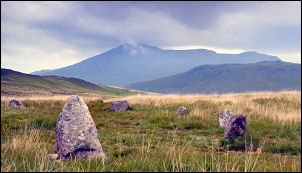
Here is where I wanted to investigate the group of stone circles that the map shows. I soon found the natural stone outcrop that indicated their position then came across the interconnecting paths that link them. They were large in diameter but not very high, so difficult to photograph. I headed out to the NW towards Low Longrigg to find some more but the absence of any path and very rough ground made the going quite difficult. I found a small circle but I’m not sure I was on the right one so I headed straight for Boat How and higher ground. At one point I stopped for a coffee but didn’t get chance to finish it because the overcast muggy weather made it the perfect place for clouds of midges. They descended on me in great numbers and there was no question of me hanging around. |
|
|
|
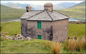
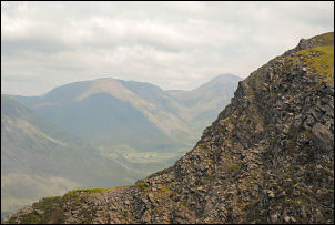
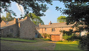
I speedily set off towards Burnmoor Tarn and Burnmoor Lodge just above it. The building is quite substantial and securely locked and boarded up. I walked past and headed for the SW end of the tarn then straight up the steep climb up Illgill Head. About half way up there was a slight breeze and I reckoned I would safe from tormenting midges. I was right; I sat by a boulder and ate my sandwiches with the expanded views below. |
|
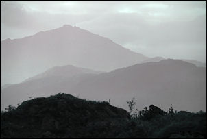
The muggy weather made for a hazy view but I didn’t mind, it was pleasant just sitting there. I set off again on my direct ascent. The gradient eased and I found myself on the final approach to Illgill Head. I’d done the hardest part of the walk and now there was a flat undulating path all the way to Whin Rigg, except for the last bit. In places I kept to the ridge edge so I could see down into Wast Water but the haze meant that I couldn’t even see the coast. |
|
|
|
Over the top of Whin Rigg I had a nice view of the sweeping curve down to the top of Greathall Gill, which I passed and carried on to Irton Fell. Part way down a gate and stile leads off to the left and a trail through a tunnel of pine trees. This was my descent route so I took the dark tunnel and followed it till out into daylight again. A nice winding path took me down to a forestry track which then took my back to the car park in Miterdale. |