|
Kilnsey, Arncliffe Cote, Street Gate, Mastiles Lane. Yorkshire. Thu 24 July 2007 |
|
|
I had a nice sunny drive to Kilnsey in Yorkshire. I parked my car almost opposite the Tennant Arms and headed north under Kilnsey Crag and a blue sky. Just before Skirfare Bridge I took the left turn to head up Littondale along the minor road. The going was fast and easy but the road was quite narrow and I constantly had to stop and squeeze up against the wall to let vehicles pass. Across the valley and up onto Hawkswick Moor were very good views of ancient field systems and their terraces of levelled ground. |
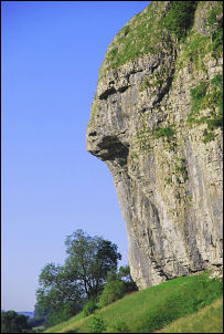 Kilnsey Crag. |
|
|
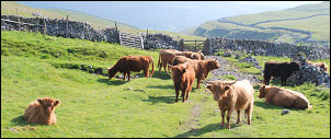
At Hawkswick Cote is an extensive caravan park with some camping facilities. It’s a site I’ve used several times in past years but only for camping. Just after the entrance I left the road and headed up a track by Arncliffe Cote houses then along a walled lane onto the open fell. As I got higher I had nice views across Cote Gill to Scar Bank. Thankfully the good weather continued and at the head of the valley I left the path for a while to have a look down into the deep river valley. After rejoining the path the gradient eased and I entered a field with some fierce looking, but very placid, highland cattle. They hardly moved a muscle as I passed by and seemed totally unconcerned about my presence. |
|
I hadn’t gone too far before the distant view of Angram Reservoir dam appeared. That reservoir is much older, being opened in 1918. Towards the end of the stone track was a ruin on the left called ‘Lodge’. It is shown on the 1850s map so predates the reservoirs. I noticed a tent pitched below, on a flat piece of grass by the reservoir bank. I’m surprised they haven’t been moved on by the authorities, or perhaps they just haven’t been seen yet? The track then turns sharp right and straight up the hillside to the pass summit. |
|
|
|
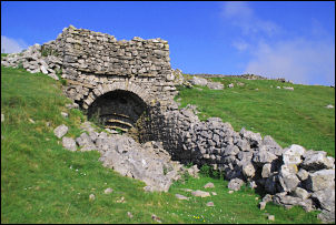
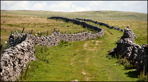
I was now crossing Low Lineseed Head and saw some limestone blocks a little higher on the horizon. I climbed to investigate and came to a very nice old limekiln. Its front construction was fairly unusual. A short steep climb followed then I was on fairly flat ground which was a delight to walk on. At the next gate I had reached the high point and was able to see across towards Malham. A winding track took me down to Gordale Beck, which I presume runs into Gordale Scar below. Across another field I came to Street Gate which joins the tarmac road to Malham village one way and Malham Tarn the other. I took neither way and turned sharp left along Mastiles Lane which is a green way back to Kilnsey. I hadn’t gone far when a cyclist approached from the other direction. He stopped to ask if I knew what a skylark looked like. Perhaps he saw me carrying my tripod and thought I was birdwatcher. We chatted for a while and it turned out he was fairly local, from Threshfield, and was an artist. |
|
He continued his way west and I continued east. After crossing a stone footbridge I climbed up a short way to the edge of a Roman Camp. The outer wall could be clearly seen and instead of following the path through the middle I followed the Roman wall to the left. I rejoined the path and continued along Mastiles Lane. This was a much more popular path than earlier in the day and I met several groups of people. At Mastiles Gate I started the steep descent to Kilnsey. Below I could see a couple of groups of young people with large rucksacks walking up towards me. |
|
|
|
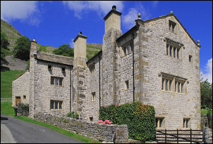
After a long descent I came to tarmac and then the village of Kilnsey. The first major building I came to was Kilnsey Old Hall. It is very impressive and most of the existing building dates back to the late 1640s. An interesting fact I wasn’t aware of is that Lady Anne Clifford stayed here in 1663 and 1666. A short distance ahead I reached the main road and my car. |