|
Kirkstone Pass, Red Screes, Fairfield, Helvellyn, Great Dodd, Cumbria. Tue 31 July 2007 |
||||
|
With high pressure sitting over part of the UK I thought it would be a good idea to investigate the one way walk over the high route from Kirkstone Pass to the Old Coach Road above Dockray. I’d hoped to do the walk last Sunday 29th July with some friends, but for various reasons it didn’t happen. Organising the logistics of getting to the start and back from the finish would have been easy with more than 2 cars. Today I’m on my own so the logistics need a bit more thought and effort. I’d arranged to leave my bike at the Kirkstone Pass Inn. So my first call was at the Inn. I arrived at 7:20am and left my rucksack and boots round the back. Then I drove on to the small car park at the end of the Old Coach road above Dockray. I unloaded my bike from the car and cycled back to the Kirkstone Pass Inn. It sounds easy saying it like that but it was 10 miles and the last 2 were the stiff climb of Kirkstone Pass, 300m or almost 1,000ft of winding road. I felt like I’d already done an epic when I got to the Inn to leave my bike and recover my rucksack. |
||||
|
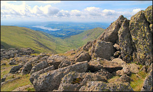
The weather was just right, sunny with some cloud and pleasantly cool for walking. I was underway by 8:45am and crossed the road to head up the steep climb of Red Screes. The path has been much improved by the Pathfairies, that wonderful group of volunteers who construct good stone paths to aid the walker. The steeper sections were relatively painless and large stone blocks had been used to make a steady stepped route. I reached the summit to wonderful views and a panorama that had Helvellyn away in the distance. It was a bit daunting when I realised that was only about the half way point on my route. I left the deserted summit behind and followed the wall down to Scandale Pass. This is another occasion where the Ordnance Survey map has the path totally wrong. They show the route as almost a straight line but there is nothing on the ground where they show the path and probably never was. |
 Red Screes summit & trig post in the distance. |
|||
|
|
My next objective was the large cairn on Scandale Head. With the good weather it was an easy stroll, but on past walks it has been difficult in poor visibility conditions. I left the obvious path here and took a guessed line to the summit of Hart Crag. The summit was out of sight over the horizon but I wasn’t too far out when it came into view. There is a tumbled down wall to follow all the way to the base of Hart Crag. It drops down then up again into a mass of large boulders. It was here that I met a walker coming the other way. Such a nice day is bound to bring many people out. I reached the large cairn on the summit of Hart Crag to find it already occupied by two walker sitting behind it to shelter from the wind while they had something to eat. |
|||
|
The summit of Fairfield was in my sights so I pressed on. The wind had got up a bit and the temperature was only 13degC but it was still pleasant to walk in. A few people were wandering around the flat summit area when I arrived and before descending the steep path down to Grisedale Hause I wandered over to look down Cofa Pike and across the magnificent huge whaleback shape of St Sunday Crag. The descent to Grisedale Hause was steep and very loose in places. The crumbly gravel had no consistency to it as it normally has in damp conditions. Walking down the easy path to Grisedale Tarn was quite crowded. I was even held up in a queue for a while as a group of women negotiated the stepping stones across the outlet river. As with Red Screes the steep climb of Dollywagon Pike was much easier than it looks from a distance. Once again the path had been much improved by large solid stones having been used to form a staircase. |
|
|||
|
|
By now it was mid-day and time for lunch. Just before the summit is a nice grassy ridge with a shelf a few metres down to shelter from the wind. There is also one of the best views in Lakeland, looking down Grisedale towards Patterdale and Place Fell. The worst of the climbing was over but I still had a long way to go. The path onwards is well made and well used. There were many people on the flat summit of Nethermost Pike and as I looked across to Striding Edge I lost count of the ant like dots crawling across its sharp profile. |
|||
|
||||
|
As I followed the path up the final climb to the Helvellyn summit shelter I looked to my right to see the memorial to the first landing of an aircraft on Helvellyn in 1926. Many people were about but nobody else seems to have noticed the marker. As expected the summit shelter was full of people sheltering from the wind. It felt chilly because the 13degC temperature so I kept on moving to the trig point. |
|
|||
|
|
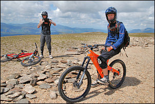
Nearby where a couple of mountain bikers who were having a great time in the excellent visibility.
|
|||
|
|
A little further on I came to a lone path worker digging out to set stones in the hard summit plateau. I asked him why a path was being constructed on almost solid rock. Apparently it was more to do with guiding people in the right direction than providing a firm footing. I had to pause for a while to take in the magnificent panorama. I could now see virtually my entire remaining route to Great Dodd, which looked a long way off. At least there is a good path all the way and no particularly steep climbs. There was one steep descent though and that was my next objective. Once down I followed over the rounded dome of Whiteside and down to the branch path that leads to Glenridding. My way was straight on over Raise and down to Sticks Pass. The path up to Stybarrow Dodd marks a change in the landscape. There is much more grass about as opposed to the fairly barren terrain since Hart Crag. |
|||
|
I visited the cairn on Watson’s Dodd to have a good view down to Keswick and across to Skiddaw. The last climb of the day was now ahead, the easy route up Great Dodd. The wind had picked up a bit but I was unable to get in the stone shelter because it was full of people. Never mind, I had a great panorama of the Skiddaw and Blencathra range in from of me. The long grassy descent to the Old Coach Road was in front of me but the lower sections were quite wet in places. Even though it was now mid afternoon people were still climbing up. I finished the walk to find the car park full which had been empty when I first arrived this morning, which seemed a very long time ago now. |
|
|||