|
Arncliffe, Fountains Fell, Pen-Y-Ghent Gill, Yorkshire. Wed 12 Sep 2007 |
|
|
I had a pleasant drive to Arncliffe, in Littondale. Leaving the Skipton area there was quite a bit of morning mist around, and I could see the orange disk of the sun rising as I approached Grassington. By the time I reached Kilnsey I was in sunshine but as I arrived in Arncliffe a high veil of cloud made for an overcast start. I left my car in Brootes Lane and headed off up the road towards Malham. I had a few miles of road walking ahead but there was very little traffic and the views were quite nice so the miles passed pleasantly. After a steep climb the road levels out then a very steep descent took me down to Darnbrook House. It’s strange how the mind wanders when walking and mine went back many decades to my first visit to this road in about 1965 when I was with a group of cyclists from the Ribble Valley Cycle racing club and our Sunday run that day took us from Stainforth, over this road, and home via Arncliffe. At the branch track to Tennants Gill I joined the main Pennine Way path. It was the ideal spot to stop for a coffee break before heading up towards the farm. As I passed the farm buildings I even got a friendly wave from the farmer, which was a pleasant surprise. |
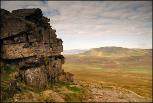
 Ingleborough and Pen-Y-Ghent from Fountains Fell. |
|
|
The path was soft grass at the start and as I got higher there were sections that had been repaired with what looked like imported stone. The path did a fair bit of winding around and when I got near the summit it did a lot of up and down as well. This was my first time on this side of Fountains Fell. In the distance the high point was marked by a couple of tall cairns. The map showed Fountains Fell tarn to my left but I couldn’t see it. Even when I reached the cairns there was no sign. A nice view of Pen-Y-Ghent and Ingleborough appeared in front of me. It was the perfect place to stop for my butties. A lot of spoil heaps were scattered around and the map shows this as an area of abandoned coal workings. Over the wall the path started to descend quite steeply and I had a great view down into Pen-Y-Ghent Gill below. Judging by the size of the path and the ditch by its side it was probably one of the main access routes to the coal pits it times past. I was soon down at the road and turned right until I came to a green track that followed the contour. |
|
I followed it NE and enjoyed the leisurely wander with nice views ahead. The walking was very easy and in the distance I saw the first walkers of the day approaching. The nearer I got to Littondale the more people I saw. The final descent was a rough stony lane between stone walls. I reached the valley bottom at the bridge over the River Skirfare and was surprised to see the river bone dry. I didn’t cross over to the road but kept on the path to the outskirts of Litton. Keeping by the riverbank I came to Scoska Wood which a notice board said was the largest Ash woodland in the Yorkshire Dales. The path was quite close to the river in places and I wondered what it would be like getting through when the river had water in it. Eventually the path retuned to the fields and the landscape opened up nicely before the path joined a track which took my back to my start point at Brootes Lane, Arncliffe. |
|