|
Halton Gill, Pen-y-Ghent, Plover Hill, Foxup, Yorkshire. Tue 18 Sep 2007 |
|
|
The weather forecast for my usual Wednesday walk was poor so I am walking on a Tuesday as this one is better. I am continuing my exploration of the side fells from Littondale and this morning I had a pleasant drive via Skipton to Halton Gill at the head of Littondale. It was much colder than of late and as I parked the car the temperature was still only 4degC. I walked the short distance along the road to Halton Gill Bridge. The sun hadn’t reached the valley bottom yet so it was still quite cold. I squeezed through the narrow gate hole in the wall and followed the path close to the bank of the River Skirfare, thought the name river wasn’t accurate as it was bone dry. The path left the river and headed off into the fields, passing a line of barns which the map refers to as Heber Side Barns. At Nether Hesleden I left the fields and joined a short track, then through a gate to a group of private houses, one with a date stone of 1703. |
 Nether Hesleden |
|
|
The footpath route wasn’t clear and I only found it by accident. It followed a diagonal line up until it came to the road. The road ahead was flat, deserted and had a nice view of Pen-y-Ghent in the distance. As I got closer I began to wonder which would be the best way to the top. I’d intended following the road and follow the traditional route via the Pennine Way. However, the SE face looked very inviting and it looked like I could get to it without having to scale any walls or fences. When I got to the area known as Giant’s Grave I left the road and headed across rough open round towards the mountain. After crossing Crooke Gill I headed for a wall that ran steeply up the fell. I hadn’t been climbing long before the wall became quite dilapidated and I was able step over it and onto the open hillside where I was able to continue climbing above the limestone outcrops and onto the grassy summit. |
|
The views were excellent and a nice minor path took me along the contour until the summit trig point came into view. As I approached another walker was arriving from the main path. An interesting seat feature had been build into the wall but I didn’t stop to try it out. I crossed over the wall and followed it due north, avoiding the main path which descends along the Pennine Way and down to Hull Pot. The weather was improving a bit and I had a nice view ahead, all the way to Plover Hill. There was a cold westerly wind so as soon as I came to a gate in the wall I went through to get some shelter and have a very pleasant break to eat my sandwiches. The path continued along the wall and didn’t seem particularly well used. The summit of Plover Hill was something of an anticlimax as it was marked with just a wall and stile. I continued north across the grass until I came to the wall that drops steeply down Foxup Moor to a bridleway below. |
|
|
|
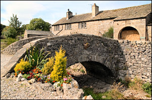
The path was quite steep and there were nice views of Ingleborough to my left. I reached the track which is a through route from Foxup to Horton-in-Ribblesdale. I turned right along the track and followed it along the contour then it headed down the fell to the small hamlet of Foxup. I reached the road at the point where it terminates and stopped for a while to look at the buildings. I headed back to Halton Gill along the road and instead of just returning straight to my car had a look round the interesting collection of buildings. |