|
Ribblehead, Cam End, High Green Field house, Cosh Outside, Ling Gill, Yorkshire. Wed 03 Oct 2007 |
|||
|
|
|||
|
I drove to Ribblehead and continued on the Hawes Road for another mile and a half to where the Dales Way path meets the road. I parked the car and set of east along the Dales Way. A short descent took me to Gayle Beck where a new-ish looking footbridge had been built. When I walked the Dales Way about 20 years ago I seem to remember wading across the river here. There was no need for that now as I didn’t even need the bridge. The river was almost bone dry. A short way downstream the beck is called the River Ribble. I wonder who decided at which point the Ribble starts. On the far bank the track is quite substantial and is also shown as a Roman Road on the map. |
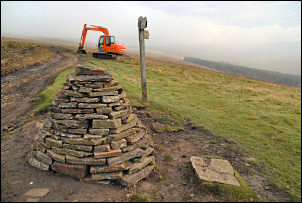
 Excavator on the Roman Road. |
||
|
|
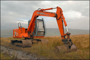
I soon came to some excavating machines and various other equipment. It looked like a lot of money was being spent on levelling the track but as it’s not adopted I wondered what the purpose is? Near the top of the rise at Cam End the track joins the Pennine Way. The views were disappointing due to haze but at least it wasn’t raining. I continued to see more machinery and some fairly messy stretches of track. Eventually it settled down and at West Gate I was on a nice firm track. A signpost showed me where the Dales Way leaves the main track and I followed it diagonally down towards Cam Woodlands below. Somewhere ahead was Cam House but I couldn’t see it because of the trees. |
||
|
The map shows the path going through the trees but I decided to give that a miss and walk round. Cam House came into view and I rejoined the path to reach it. This is where I met the first walkers of the day, two men coming the other way. The map shows a path heading south towards Cam Rakes but there was little evidence on the ground. By the time I’d reached Cam Beck at the valley bottom there was no sign of a path. I did at least have some quad bike tracks to follow up by the wall. I kept an eye out for a path that is supposed to head through Low Green Field Lings, but could see no sign. |
|
||
|
|
The woodland plantation looked pretty impenetrable and I wondered where to head for next. To the SW was a crumbling wall through a clear avenue. I set off along it but soon wished I hadn’t. The going underfoot was a nightmare of tussocky haggs and invisible potholes between them. After what seemed an age I came to a clearing in the trees to my left. It headed down to where I knew there was a forestry track so I took it and hoped for the best. It wasn’t too bad and eventually the track came into view. When I reached it I turned right, hoping I’d find a way down to High Greenfield House. In the distance I saw a Landrover and trailer and when I reached it a man was just packing away a rifle and telescopic sight. I stopped to chat for a while. He was in the area for a few days hunting. But today’s still conditions weren’t good for hunting and he was packing up for the day. |
||
|
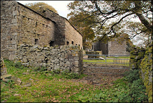
I carried on along the track and eventually came to a footpath marker which pointed roughly in the direction I wanted. I followed it through the trees until I came to another track at a stone bridge. I turned left until I came to High Green Field buildings. I couldn’t see anyone about but I decided to keep out of sight in case I wasn’t on a public footpath. I was heading for Cosh Outside summit but had some fairly dense forest to get through first. The map shows a direct path running up the hill. I saw a gap in the trees and headed for it. For a while the going wasn’t too bad. There was a strange score mark in the grass which puzzled me for a while until I reached a drainage ditch and saw a blue plastic pipe on line with the marks. This was a mole ploughed water pipe which looked like it hadn’t been in the ground for long. I continued climbing up until I reached a wall shown on the map. There should have been a way ahead but all I could see was a mass of blown over pine trees that formed a dense wall in front. I tried several ways to get through but failed. It brought a new meaning to ‘impenetrable’. |
|
||
|
|
I had no choice but to
reverse my way back down to High Green Field and turn back along the
track the way I had come. Passing over the stone bridge I continued to
the next gap in the trees. I followed this up and eventually reached a
fence and open fell. I breathed a huge sigh of relief and continued
straight up the fell to the stone pillar at the top. The wind had got up
a bit so I sat behind the wall to have lunch. There are few tracks in
this area and it is not wise to leave them because of the very difficult
ground conditions. I followed the trail down to the SW which I have used
before. I found a reasonable way down Birkwith Moor and then on to the
Pennine Way at Old Ing. Here I met a mountain biker and we had a brief
chat before I continued past Ling Gill and on up the moor again to Cam
Fell. I now met the Dales Way where I had walked earlier in the day and
descended back to Gayle Beck and my car. On the way some of the machines
I had seen earlier were working. |
||