|
Kingsdale, Gragarath, Whernside, Yorkshire. [22.3km] Thu 29nd Nov 2007 |
|
|
With a fairly traffic clear drive I arrived in Kingsdale about 7:15am. Daylight was still slowly emerging as I set off back down the road and then through a gate below Hunt’s Cross and up onto the fell. I joined an old track and plodded steadily up with little to see because of some cloud still swirling around. I was heading in a NW direction towards Marble Steps Pot and it is the first time I am using my new 25K map of this area. I find the new colour scheme that the Ordnance Survey has adopted is pointless and obscures vital details on the map. Why do they do such daft things? |
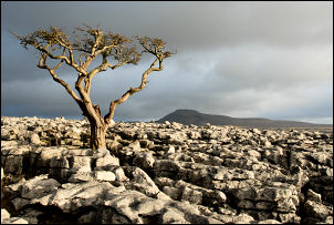
 Ingleborough from Gragarath. |
|
|
Approaching Marble Steps I was also approaching mist and light rain. I looked behind to see Ingleborough summit being swept with cloud. So much for the sunny day the Met Office had forecast. It was wet rushes after the pot but eventually I reached the wall which leads up to Gragarath. Following the right side of the wall the going was variable and quite wet in places. I kept climbing steadily and then was in thin cloud. As the gradient flattened I inspected some interesting cairns to my right. The way onwards was still fairly boggy but following the wall at least I wouldn’t get lost. A came across 3 chairs against the wall which must have been brought up for a reason but I can’t think what it could have been. |
|
At Green Hill I turned right and followed the wall down. The gradient soon got rather steep and as I lost altitude I dipped below the cloud and had a bit of a view down to White Shaw Moss. I sat down for a while to enjoy the scenery before continuing. I joined the freshly stoned track at Foul Moss and followed it to the road. I turned right and followed it to the path to the left which leads up to Whernside. As I climbed I didn’t walk into cloud again. The wind had got up but the cloud was blowing away giving some clear patches. By the time I reached the summit Trig Point I had a fairly good view, but no sunshine yet. I also met some people for the first time today. They were sheltering behind the wall and having something to eat. I didn’t stop but turned right and set off down the main path towards Ingleton. |
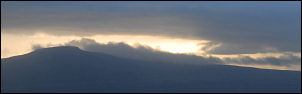
 Ingleborough from the descent of Whernside. |
|
|
The main descent route is down to Bruntscar but I left that path and continued along the wall for a more direct line back to my car. There was a minor path there but it was quite wet in places. Eventually I left the bog behind and was walking on limestone escarpment. The views across to Ingleborough were now very nice in the changeable weather. At the end of the Limestone I made the short, steep descent to Twistleton Lane, which is a track, and followed it right to a ford and footbridge over the River Twiss. Just over the footbridge I returned to my car. |