|
Bootle Fell, Black Combe, Sunkenkirk Stones Circle, Cumbria. [20.1km] Wed 26th Dec 2007 |
|
|
Today is Boxing Day and the morning drive was a good time to be on the roads as there was hardly any traffic. A couple of miles after Duddon Bridge I managed to find the right turn off from the A595 which took me up towards Cragg Hall. The lane is quite narrow and there is only one place to park a car. It was still dark when I arrived and getting my stuff ready always seems to take twice as long in the dark. Eventually I was on my way and heading along the lane towards the fell tops. The first building I came to was Crag Hall which has two spellings on different scale Ordnance Survey maps. 1:25000 shows Cragg Hall while 1:10000 shows Crag Hall. |
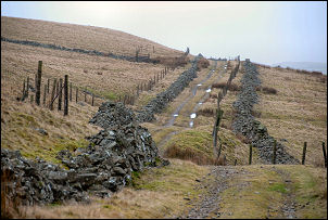
 A wet Thwaites Fell summit |
|
|
The weather was heavily overcast and rain is forecast for later. I reached the road over Corney Fell and turned left to continue my miles of road walking. As I got higher and could see where Black Combe was supposed to be all I could see was cloud. The map calls the area Thwaites Fell but I’ve always known in as Corney Fell. Just over the summit I took a rough stony track off to the left. I had a good view out to sea and could see the white waves foaming along the shore as the wind was getting up. Further down the track I came to what looked like old quarry workings on my left. Many motorbike tracks criss-crossed the area looking like it was used for motorbike scrambles. |
|
I left the track and headed left across rough and very wet scrub until I reached Crookley Beck and a small ford. There was some shelter from the wind here so I stopped for an early lunch. I then followed a path to the SW until I came to a wall which I followed to what looked like one of the main paths up to Black Combe. I followed it upwards but was soon in cloud. I wanted to make the ascent by a different route than the path so soon had to strike off in a different direction just using my compass to keep me in the right bearing. It seemed to take ages but eventually the gradient eased and I realised I must be near the summit. |
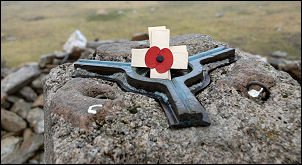 Black Combe trig point and poppy. |
|
|
I crossed the main path over the top and headed for where I thought the summit trig point would be. Eventually I saw its profile appear through the mist and was soon there. Just as I was leaving a couple of walkers arrived, the only people I was to see on the fell all day. I still had no visibility so set off on a compass bearing heading NE towards Whitecombe Head. At an altitude of abut 450m I came out of the cloud and was able to see my way ahead. The path continue for a while but I had to leave it to find the fence that would take me towards Swinside Fell. |
|
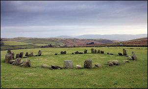
I descended towards Raven Crag and came to the stone wall which for some odd reason does not have any crossing point. It appears to have been repaired in several places and I’m sure a crossing ladder would prevent people having to scramble over. The final descent to Swinside Farm is quite steep but it is worth stopping on the way down to take in the wonderful view of the 28m dia. Sunkenkirk Stone Circle. Once at the farm I came to the farm track which I followed past the stone circle and back to the car. |
|