|
Moorahill Farm, Heltondale,
Helton Fell, Loadpot Hill, Bampton Common, Cawdale, Cumbria. |
|
|
After a dark drive along the M6 I left at Shap and took the lanes to Bampton where I took the narrow steep lane up to Moorahill Farm. As I approached the end of the lane a fox was trotting along the in front of me. I set off walking along the gated lane to the north towards Rough Hill. Its a few years since I’ve been this way and the renovation of the building doesn’t seem much different. Where the lane reaches open ground at Cockle Hill there is a red post-box in the stone wall. It is so remote I wonder what sort of use it gets. |
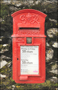 The Post Box |
|
|
I then took a rough track west towards Dalehead until I reached a gate where a path follows the wall side to the left. At the high point I stopped to look down Heltondale and noticed a minor track going through the rushes towards the wall. It was the way I should have gone but missed it. I descended to the valley bottom and Heltondale Beck. I crossed over and soon found gates to take me back down the valley to join the path I should have been on. There was a nice stone bridge over the river but my way wasn’t over it. I followed the path across the fields up a walled lane to Scales Farm with a 1763 date stone over the door. Some of the stone buildings seem to have window frames made of much older dressed stones, probably reclaimed. |
|
I reached the tarmac road again and turned left across very wet ground towards Knotts. It’s a low summit which is much less impressive than the map indicates. It is quite a pleasant spot with nice views. I crossed Anna Sike and followed a nice track up onto the moor. |
 View across Heltondale |
|
|
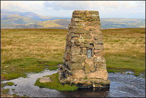
It climbed steadily up Helton Fell and I eventually came to High Street and then had a nice view of the fells to the west as well as east. The weather was a bit mixed but rain hadn’t started yet. The cloud remained high so I was able to get good distant views of my next objective, Loadpot Hill. The main path follows High Street to the right of the Hill but that means missing the summit trig point. I left the path for a while to investigate an interesting depression called Loadpot Hole. From there I took a direct line to the summit and trig point. Continuing south I came to the remains of Lowther House, which used to be a shooting lodge. The base of the stone chimney and some of the concrete flooring is all that remains. |
|
I continued south to Wether Hill and turned left to head SE towards Bampton Common. I kept an eye out for the path that the ordnance Survey shows is in the area but couldn’t find any sign of it. When I reached the edge Bampton Common above Measand Beck I came to the main path up the fell. I found the old boundary stone shown on the map and continued my descent via The Hause towards Cawdale. It was here that the heavens opened and it poured down for a short time. I also met my first people of the day, a couple walking up as I came down. I had a look at the Kowtop Kirk stone circle then crossed Cawdale Beck at the footbridge composed of huge stone slabs. Crossing the field I came to Moorahill Farm and back to the car. |
 Stone slabs crossing Cawdale Beck. |