|
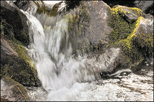
Seevy Rigg, Brant Fell, Arant
Haw, Crosdale Beck, Cumbria. |
|
|
Howgill Lane to the west of Sedbergh is very narrow along most of its route but there is just enough space at the SW of Winder where the track leaves the road to squeeze a couple of cars in. I managed to get mine in early and set off in the windy conditions. There were clear patches between the clouds but the only sunshine I could see was in the distance. Heavy rain was also forecast. I walked up the walled lane and turned north (left) through the gate at the top. |
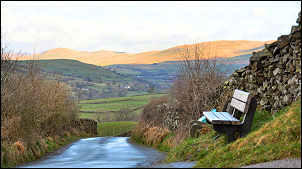 Howgill Lane towards Greyrigg |
 Wall along the west side of Winder |
The map didn’t show a path but there was one which was fairly distinct. I continued to Craggstones and crossed Crosdale Beck. The views up the Lune valley were very impressive and I wondered if the distant sunny patches would reach me before the rain did. The path continued at about the 300m contour until I was above Birkhaw. At Swang Head I descended steeply to Bram Rigg Beck to join the main track across the beck and up to Bram Rigg. |
|
Up ahead I had a clear view of the Horse of Bush Howe, a strange shape formed by loose rocks on the fell side. I descended to Calf Beck and walked up the valley to investigate a feature called ‘Hut’ on the map. I thought it may have been and old shooting hut but when I got to the spot there was no sign of anything. No ruin, no foundations, absolutely nothing. |
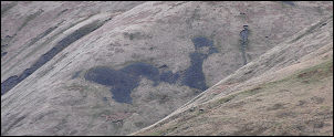 Black Horse of Bush Howe. No, its not man-made! |
 Bram Rigg towards White Fell. |
The summit has a small cairn but is generally very unimpressive but the views were excellent. I didn’t stop because of the crowds. At Skelgill Bank I descended down to the right to the old track above the road. I followed it to the cattle Grid at Hawes End and then into the woods and down to Derwentwater at Kitchen Bay. The main path stays close to the lake but I left it south of Wythsike Bay to head up through the trees as I was looking for a memorial plaque which is supposed to be in the area. |
|
I climbed back up to Bram Rigg and over to Bram Rigg beck and on to the sheepfold at the base of Calders Rigg. Behind it walls I was able to sit out of the wind and eat my sandwiches. The walk up Calders Rigg was quite windy and when I reached the main path at the top I turned right to follow it towards Arant Haw. |
 Bram Rigg Beck. |
|
|
The branch to Arant Haw summit isn’t obvious but I took it and wandered over the summit and on towards Middle Tongue. The views were excellent and in spite of high winds and high cloud the distant views were very clear. I took the steep descend down to Crosdale Beck and wandered down the valley to rejoined the path back to Howgill Lane. |