|
Hebden Bridge, Heptonstall,
Stoodley Pike, Todmorden, West Yorkshire |
||||
|
Caught the 7:18 bus into Chorley. The price has now gone up to £1.70 which is a 17.5% increase. I was planning to catch the 8:11 train to Preston but as an earlier one was there I caught it. I just missed the Hebden bridge (Blackpool to York service) by 15 seconds so had to sit and wait almost an hour for the next one. The route goes via Blackburn and Burnley through some very picturesque countryside and the dramatic Cliviger Gorge between Burnley and Todmorden. The sun had come out when I arrived and by 11am I was on my way. |
 Hebden Bridge railway station |
|||
|
|
|
|||
|
|
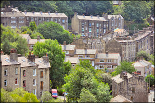
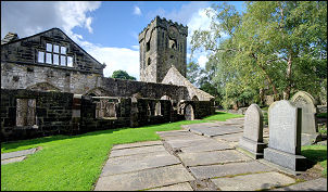
The A646 main Burnley Road in Hebden Bridge was quite busy and took a while to cross. I headed up the A6033 Commercial Street and marvelled at the incredible amount of work that was done to build the stone houses on such a steep sided valley. I turned down Foster Lane to descend to Foster Mill footbridge over Calder Water. I had now left the town and was in countryside. A very steep cobbled path took my up through an interesting collection of buildings and then up to the main Lee Wood Road. A minor path took me up through Tinker Bank Wood and then a narrow overgrown lane to Heptonstall Methodist Chapel, reputedly the oldest Methodist Chapel in the World in continuous use. I crossed the village cobbled street and up a ginnel to the ruins of St Thomas a Becket church. |
|||
|
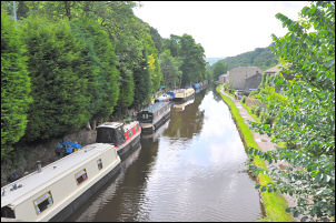
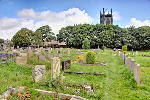
I wandered around taking a few photos before looking at the adjoining Parish Church and taking a few more photos. It was worth a visit to the current churchyard as the grave of Sylvia Plath (1932 – 1963) the poet and writer, is at the far end. I could have spent more time in the village but had to leave as my main walk was still ahead. I descended the cobbled street down to Hebden Bridge again, crossed the main road and headed across the Rochdale Canal at Hebble End Bridge. |
|
|||
 Heptonstall Parish Church |
 Heptonstall Parish Church interior |
|||
 The grave of Sylvia Plath |
 Heptonstall side passage. |
|||
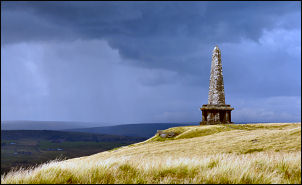
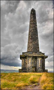
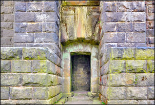 Entrance to Stoodley Pike monument. |
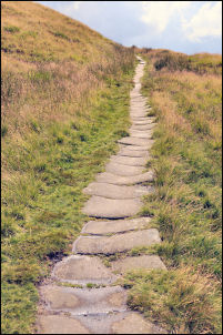
Turning right is a very steep lane which goes to Horsehold Road and then to the Horsehold Farm buildings. I followed a lane by Bents and Broad lane to Kilnshaw lane where the steep climbing seemed to be over. I now had a level walk for a while and could see my objective, Stoodley Pike Monument, in the distance. At the buildings of Swillington the vehicle road stops and a rough track takes over. A signpost points left and I climbed steadily up a muddy path to the moor plateau. I then had the impressive sight of the 37m (121 ft) tall monument in front of me as the rain started. |
|||
|
I reached the entrance to the staircase just as the rain became torrential. Fortunately it didn’t last long. The stone stairway was pitch black so I need my torch to follow it up to the balcony but there wasn’t much of a view through the driving rain. The entrance was quite sheltered so it was the ideal place to stop for my lunch before continuing along the ridge path. Above Mankinholes is a very nice descent path which the map calls Long Causeway. |
|
|||
|
||||
|
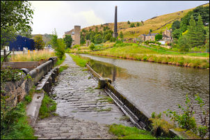
The views down to Todmorden would have been impressive except for the cloud and incoming rain. The torrential rain hit just as I was on the final descent to Lumbutt’s Clough. I reached the road and on to the Rochdale Canal. I was heading for the Railway Station but decided to take the canal towpath for a while as it would be much quieter than the road. The rain continued but not as heavy. At the next bridge I left the canal and joined the main A646 road into Todmorden and the Railway Station. I didn’t have long to wait as the Manchester Victoria train arrived within 10 minutes. As it trundled to Manchester I looked out at driving rain on the roads, thankful that I’d finished my walk just in time. |
|
|||