|
Seathwaite, Sty head, Great End,
Grains Gill, Cumbria. |
|
|
NY 2350 1221 |
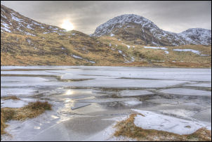 Styhead Tarn |
 Great Gable and Green Gable from The Band/Great End |
One major advantage of frozen and hard ground is my boots keep dry. The path to Styhead Tarn and Styhead is notorious for being awash with water, but not today. I stopped briefly at Styhead Tarn to take in the impressive grey sky reflected in the iced over tarn. I continued up to Styhead summit as far as the First Aid Box then turned left to head across towards The Band. The ground was nice and hard due to the frost so the walking was easy. I kept on the path towards Sprinkling Tarn but turned off to the right before reaching it. The Band is a good northern approach to Great End but there is no obvious path. I was soon on the ridge heading steadily upwards. |
|
The snow patches were getting larger so a stopped for a coffee at a flat spot and took the opportunity to strap my ice studs on my boots. I hadn’t been going long before I was glad I had as the snow was hard and steep in places. I continued up to the top of the first climbing gulley where a solo climber just emerged after climbing it. He saw me and asked the best way down. I told him to follow my tracks back down The Band. Without hesitating he followed my advice and headed down. I continued up and was soon on the summit plateau of Great End. The whole area was like the top of an iced cake. The surface was very hard and easy to walk on. I had a quick look at the summit cairn then crossed the flat to the east edge where I stopped for a while to take in the wonderful views across to the Langdales. |
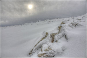 Icy summit of Great End |
 The Langdales from Great End |
I started my descent towards Calf Cove along a route I’d taken many times before. I was expecting an easy walk but I was soon halted my a steep snow slope covering the stepped path. I decided to leave it alone and return to the saddle and make a rougher descent more to the north but not as steep and exposed. Once down to the stone shelter the gradient was easy and much flatter. As the shelter was almost covered in snow I was able to walk over it. I wandered down past Esk Hasue and down towards Sprinkling Tarn. I didn’t want to go as far as the tarn but take the path down Grains Gill. There are two paths that leave the tarn path and I took the first. Part way down into Grains Gill I soon realised the ice slopes were too steep and exposed so I returned to the main path and took the second and more popular route. It was still steep but there wasn’t as much steep ice. It seemed to take ages to descend the mix of frozen gravel, snow and ice but eventually I reached the wooden footbridge where the path gradient eases considerably and took me back to Stockley Bridge. It was then an easy walk back to the car. A very enjoyable walk and a good way to celebrate my 62nd birthday. |
 A lone walker heads for Esk Hause as I descend |
|