|
Haweswater, Riggindale, High
Street, Nan Bield, Harter Fell, Branstree, Old Corpse Road, Cumbria |
||||
|
NY 4694 1075 |
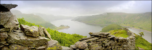
 A wet and gloomy Haweswater |
|||
|
|
||||
 Haweswater from Riggindale |
||||
 Haweswater from Riggindale a little higher up the ridge |
||||
|
There is a very good view of Haweswater from this point and I’d hoped to get some nice cloudscapes for a photo but the weather wasn’t cooperating. I tried a photo anyway. Heading higher up the ridge I was soon in cloud and had no views. Another good photo opportunity is the small tarn at Caspel Gate but that was shrouded in mist. I continued up the path to emerge at the cairn near the wall along the summit of High Street. I followed the wall to a point just short of the summit trig point and sat behind the wall out of the wind to eat my sandwiches. The summit area is quite flat and grassy and is called Racecourse Hill on the map. In mist it presents a navigation problem for the unprepared. To the SW is the main path to Froswick and SE the minor path to Mardale Ill Bell. I set off across the featureless racecourse in the direction of Mardale Ill Bell and soon came to the correct line of the path. |
 Cloud and rain on High Street |
|||
|
It had been upgraded considerably since I was last here and was now a raised stone path with side drainage ditches. I followed it easily down to Mardale Ill Bell and began to get some cloudy views below. By the time I’d reached the shelter at Nan Bield Pass the mist had returned. I didn’t stop but set off up again on the path to Harter Fell. It’s an interesting and enjoyable path but unfortunately with no views today. Over the summit I turned left to take the easy gradient down towards Gatesgarth Pass. The route follows the fence line and where it makes a turn to the right there is an excellent viewpoint for the reservoir and valley below. As I arrived the cloud cleared a bit and I was able to get a partial view. Down at Gatesgath Pass I crossed over to take the path up to Branstree. |
||||
 Haweswater from Harter Fell. Blea Water is at the top left. |
||||
|
The first part presents quite a problem as the path crosses a very wet and boggy area with no detours to keep boots dry. It always amazes me that massive amounts of money and effort are spent on main paths on the high fells where water isn’t a problem and impenetrable bogs like this area ignored. The only way across is by doing a low wire act on the fence and shuffling across with feet on the bottom wire and hands on the top wire. The continuing route up Branstree is firm underfoot and the views were good when I got to the summit. The fence meets a wall coming up from Mosedale and a short way to the left is an ordnance Survey trig point that isn’t marked on the map. It isn’t a pillar but a circular concrete ring set at ground level. I walked past the impressive tall cairns on Artle Crag then across to the tall stone survey pillar below. This pillar was one of a few used in the construction of the Haweswater tunnel which takes water from the reservoir below and takes it through the mountain to emerge in pipeline near Watchgate. A minor path continues to the NE and goes between two small tarns and over an unnamed hill towards Selside. Before Selside is a dip called Captain Whelter Bog and I’ve always wondered if it was named after a person who existed. On Selside is a large mound of stones which have been formed into a rough wind shelter. The map shows it as an ancient feature. I continued in a northerly direction then turned down the steep slop of Mardale Common. There is no path here but the ground is firm and dry so is easily descended with care. |
||||
 Haweswater from the old Corpse Road |
||||
|
I had to pick my way carefully across the head of Rowantreethwaite Beck to avoid boggy patches before joining the main Corpse Road path. I think it’s a good thing that the name survives as it give an insight in to the history of the area. The Wikipedia entry for is says:
The descent to Haweswater gives another of the classic views of Lakeland. As I descended I stopped to chat to an artist who was sat by a boulder and making a watercolour painting of the reservoir and mountains behind. His painting showed a similar view to that I’d just photographed higher up. It began to rain again so he had to quickly put his paints away. I reached the road and walked back to the car just as the rain became heavy again |
||||
|
|
||||