|
Grasmoor, Hopegill Head,
Ladyside Pike, Cumbria |
|
|
NY 1589 2077 |
|
 Crummock Water & Mellbreak from the climb of Grasmoor |
|
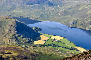 Looking down on Crummock Water |
There is no path shown on the map but it is possible to see a route up the right side of a line of scree running up the hillside. For a while there is intermittent loose ground but a sort of shelf is reached and the route becomes a bit better, if rather exposed. The climbing and scrambling continues like this almost to the western summit ridge where the ground becomes flat, grassy and good underfoot. If the weather is clear the views all the way up the climb are superb with Crummock Water below and Mellbreak behind. |
|
Grasmoor summit is a wide expanse of flat grass and the main path to Crag Hill is well used and obvious. I decided to take the lesser path which follows the northern edge of the moor above Dove Crags. There are excellent views down in to Gasgale Gill and across the Whiteside-Hopegill Head ridge was the Solway Firth and Scotland in the distance. Now I was descending to Coledale Hause and into the popular areas of Cumbria so people were now about, though I hadn’t seen anybody on Grasmoor. |
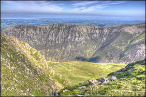 From Grasmoor looking across the Whiteside - Hopegill Head ridge |
 Descending towards Coledale Hause |
I headed north up the long haul to Hopegill Head where some people were taking advantage of the sunshine and sitting by the summit rocks and eating there sandwiches. |
|
I now wanted to follow the ridge over Ladyside Pike but the way down to it is rather steep and loose in places. It is a descent that should only be made in good weather and certainly not attempted in winter if there is any chance of ice. Though it is an ideal and exhilarating way up. Picking my way slowly down I reached the easy walk along the ridge and wandered easily NW following the wall. On the final approach to High Swinside Farm the descent becomes much steeper and when the road appears below it is very steep grass. A faint old track appeared and I followed it diagonally down to the left to make the going a bit easier. I reached the minor road and marched south with the intention of following the path along the western base of the fell. |
 Towards Ladyside Pike from Hopegill Head |
 The damaged bridge at Gasgale Gill |
Through a gate I realised I’d missed the path off the road and had to make an embarrassing retreat to return along the road to pick it up. Crossing Hope Beck there are a lot of springs running off the mountain making the path very wet in places. Once through the area it becomes a nice grassy path which winds its way south below Whiteside End back towards my starting point. At Gasgale Gill there are two wooden bridges but I followed the track down to the lower bridge which had been severely damaged by floods and no longer bridged the beck. The water was low enough to get across by stone hopping. I could see the higher bridge in the distance and it seemed to be OK. A short wander across the grass took me back to the car park, which was now full. |
|
|
|