|
Braithwaite, Outerside, Sail,
Crag Hill, Whiteless Pike, Cumbria |
|
|
NY 2323 2366 |
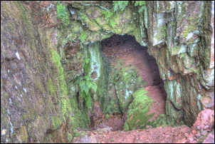 The only Cobalt Mine in Cumbria |
 Upgrading the path below Sail |
I now descended a bit before heading for the climb of Outerside via the area known as Low Moss. Although a discernable path crosses the Moss it is no way to go without wellingtons. I had to make a wide detour to keep my feet dry. From the summit of Outerside I had a good view of the north side of Causey Pike and could see a faint track. I decided to head for it and avoid the main path up to the base of Sail. Crossing High Moss I came to the path but on reaching it found that it was now just a sheep track but looked as though it was used by people in the past. I kept climbing following a fault line in the rock then came to an old mine entrance which isn’t visible from the main path below. I’d read about it some time ago and was pleased to find it as it is the 1846 Cobalt mine. |
|
Apparently there were four adits cut so the other three still remain to be found. The ground was now very steep so I traversed with care to join the main path just below Sail. A mechanical excavator was parked up and a lot of path reconstruction had been done recently including an impressive zig zag path all the way up Sail. Then followed the exhilarating path up to the trig point column of Crag Hill. |
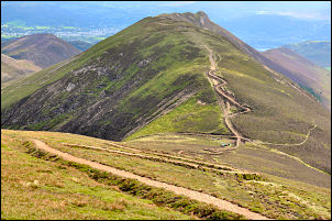 Looking to Causey Pike from Sail. The rebuilt paths are very obvious. |
 Trig point on Crag Hill |
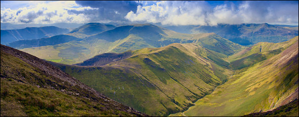
The weather continued nice and still no people were around. I turned SW to follow the edge of the fell while looking down in to Addacomb Hole which is a hanging valley above Sail Beck. I continued along Whiteless Edge then over Whiteless Pike and down the main path to the flat area at Whiteless Brest. I left the main path here and turned east to descend the steep pathless fell down to Bleak Rigg where I picked up a sheep track to take me to the path at Third Gill. |
 Looking down into Sail Beck |
|
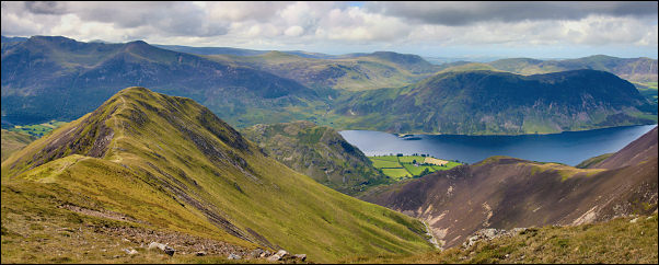 Descending to Whiteless Pike with Crummock Water in the distance |
|
|
The path follows the
contour as far as Addacomb Beck then soon comes to a fork. The lesser
fork to the left is the one I wanted as it took me steadily up to the
pass just below Sail where I had been earlier in the day. By now people
were about and several people were sat on the grass resting. I followed
the main path down High Moss and then a minor path to Barrow Door.
Looking down there were many people on the lower path by Stonycroft
Gill. I headed down the narrow path down Barrow Gill which eventually
widens to a nice grassy way. Then the stoned track took me back down to
Braithwaite. |
|