|
Loweswater, Low Lorton,
Fellbarrow, Low Fell, Cumbria |
|
|
NY 1430 2112 |
|
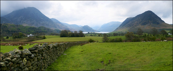 Grasmoor, Crummock Water and Mellbreak |
|
|
I turned right and enjoyed the quiet road as I wandered north. A nice clean sign welcomed me to Thackthwaite. This is where I started my walk 9 years ago as a path heads directly up to Low Fell. Today’s plan is to explore some of the fells to the north so I continued along the road to the wonderfully named Blindbothel area. To my right was a very clean looking Lorton Low Bridge. The original stone bridge was completely washed away in the 2009 floods and was rebuilt in steel and stone at a cost of £250,000. |
 Dun-cyclin' |
|
|
 Blindbothel |
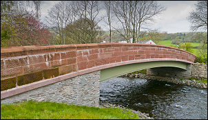 The new Lorton Low Bridge |
 Lorton Low Bridge after being washed away |
 A stone built in to the wall says: Lorton Low Bridge Built 1843 Destroyed by Flooding 19th November 2009 Rebuilt November 2010 |
|
|
I left the bridge and headed up the lane to the west. A left fork took me steeply up to ‘High Bank’ and ‘The Brow’ buildings where the tarmac ends and a stone track continues. Approaching the top of the rise are nice views out to the north. I turned left on to a narrower and rather wet track which headed out towards Whin Fell. Its route was to the east of the fell so I had to head up open fields to get to the summit. The sky was still overcast and the calm conditions I had on the road were now changing to a strong easterly wind. The summit has two names on the map; Hatteringill Head, presumably the summit area, and Whin Fell for the rest of the area. Because of the wind I didn’t hang around but descended to a wooden stile over a wall down to the south. A good path took me to the summit of Fellbarrow and the Ordnance Survey trig pillar. |
 Fellbarrow trig column |
|
The map shows it at 416m but looking to the south is the higher fell of Low Fell at 423m, which doesn’t have a trig pillar. I headed down the southern descent but soon had to make a quick detour as my map was blown out of my pocket and headed off to the west at high speed. Fortunately there was a sheltered dip in the fell and my map came to rest there, just long enough for me to retrieve it. To my left I could see the substantial track coming up from Thackthwaite and the path I was on joined it at Watching Crag. |
 Mellbreak |
|
As I walked over Low Fell I got quite a battering from the wind so at the southernmost summit I started my descent to the west and Crabtree Beck though the path continued SE. My choice of route proved the right one as I was soon out of the wind and able to enjoy the scenery. Unfortunately the low cloud and hazy views meant I couldn’t see all that much. I investigated a stone sheepfold then continued down though some gorse and across open fell to some pine woodland. There was no fence and I was able to wander easily down to the road. |
 Old sheepfold with Mellbreak in the distance |
|
By the road was an interesting notice with information about the
adjacent Pinfold. It reads: |
 The old Pinfold |
|
|
|
