|
Moffat Dale, Saddle Yoke, Hart
Fell, Swatte Fell, Dumfries and Galloway, Scotland |
|
|
NT 1541 1048 |
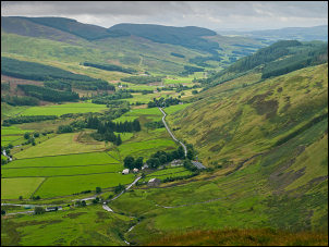 View down Moffat Dale |
|
I’d passed this way on
Tue 21 Jun 2011 on my way up Saddle Yoke and the first part of today’s
route is the same as then. |
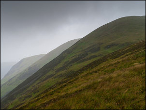 Gloomy mountains ahead |
|
Over the top is a sharp ridge to Under Saddle Yoke and though I got a brief view back to the valley bottom the wind and rain continued. However, as I approached Redgill Craig the weather began to get a bit brighter and the distant fells appeared. In the distance was Hartfell Rig but to get there I had to cross Whirly Gill. Over Redgill the ground had been rough but the descent to the higher part of the gill was better. |
 Moffat Dale from Saddle Yoke |
|
I traversed the head of
the gill and started up Saddle Craigs and was relieved to reach firmer
ground. The clouds continued to come and go but I got the occasional
view down the impressive valley of Black Hope. Eventually I came to the
fence line that took me to Hart Fell summit and the Ordnance Survey trig
post with the plate reference of: |
 Hart Fell summit trig post |
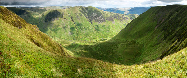 Wide view looking down to Blackhope Burn from Nether Coomb Craig |
|
|
After Upper Coomb Craig I kept to the edge of the valley top to get the best of the views. There were now impressive views down to Blackhope Burn and any doubts I had about setting out earlier were now forgotten. Above Black Crag an easy slope began to descend and there was even a faint path. I’d seen a group of walkers coming up it earlier. Unfortunately there was no sign of the path lower down and I had to pick a route carefully as the gradient got steeper. When I reached the valley bottom the rain returned and by the time I’d reached the bridge at Blackshope and the A708 it was raining very heavy. It didn’t matter as I only had half a mile walk back to the car and a change of clothes. |
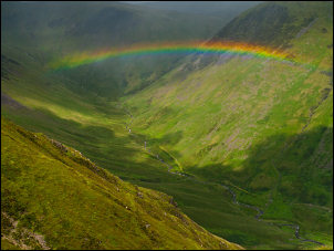 A Rainbow crosses Black Hope |
|
|
|