|
Killhope Law, Allendale Common,
Coalcleaugh, Northumberland. |
|
|
NY 7943 4443 |
 Three Counties boundary |
|
This turned out to be the correct spot and it seemed such a pathetic way to mark the junction of the counties of Cumbria, Northumberland and County Durham. The next objective was Killhope Law summit and its trig post. With no boundary fence to follow I had to continue with my magnetic compass. It was rough and boggy underfoot but the big advantage of the sub zero temperature is that the ground was mostly frozen. |
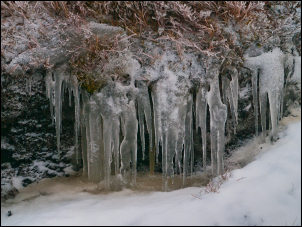 Frozen moor |
|
Eventually a small path appeared in front of me and as the ground rose up towards the summit I noticed a tall wooden pole and to the right was the trig post. The map shows a radio mast where the pole was. There was no sign of an access road for a mast so I don’t know why the map shows a wooden pole. |
 Pole on Killhope Law |
|
I was still in mist so after having a quick look at the trig post continued to a partly collapsed currick, or pile of stones. |
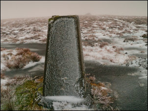 Killhope Law trig post |
|
It was originally a carefully built dry stone dome but the southern side had collapsed. |
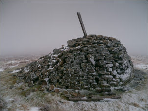 Killhope currick |
|
My next objective was a Shooting Cabin which is shown on the map. After following a compass bearing for a while I came across a path and soon reached the hut. It was a substantial stone building with its roof still on, though the windows and door were missing. Nearby were the remains of another cabin which seemed to have been made out of a timber frame and corrugated metal sheets. All that remained was part of the timber frame. |
 Shooting Cabin |
|
I started my descent off the moor along a substantial track which the map calls Carrier’s Way. At about 450m altitude I descended below the cloud and could see Dodd Reservoir to my left and the buildings of Allenheads to the right. I reached the road and turned left to head back to the car. I stopped briefly as I crossed Wainford Bridge to look at the old Thorngreen Quarry lime kiln on the opposite bank of Middlehope Burn. |
 Thorngreen Quarry lime kiln |
|
The road was very icy and I was glad I was on foot and not the bike. After a steep climb up to Scotchmeadows the gradient eased to Meadow Cottage then it was a steady plod up Shivery Hill. On the way I stopped briefly to look at the bridge across Doctor’s Hush. The base if the bridge was crumbling concrete with a parapet wall of stone. A date stone on the parapet said 1930. |
 Doctor’s Hush bridge |
|
Large areas of the road were still covered in ice and its probably a good job that I saw few vehicles as I walked the miles back to Coalcleugh. On the final rise back to the car I crossed over the fence to have a look at the old mine workings of ‘Rough and Ready’ A circular stone was in the position of a shaft shown on the map but peering over the top just revealed a grassy area and no shaft. |
 Waterfall in the mist |
|
|
|
|
|
|