|
Grange-in-Borrowdale, King's
How, Watendlath, High Tove, High Seat, Cumbria |
||
|
NY 25345 17495
|
 IN MEMORIAM W. HODGSON |
|
|
Further along I left the road and took the track to the Bowder Stone. I was surprised to see a missing rung of the access ladder near the bottom. It looks to have been broken for some time and could easily cause problems to someone coming down the ladder. It’s a pity a tiny portion of car parking charges don’t get ploughed back in to the maintenance of these structures. |
 The Bowder Stone |
|
|
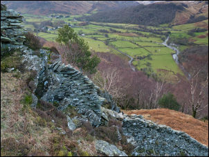
I hadn’t re-joined the road for long before I left it again to take the path steeply up below Andersonband Crag. The path was through a broken down gate without any path sign pointing it out. It’s a fine and steady climb up and gives some excellent views of the valley across to Rosthwaite. |
 View from the top |
|
 Rosthwaite in the distance |
 View from Andersonband Crag |
|
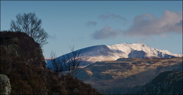 Blancathra from King's How. The distant clear sky never reached me. |
||
|
Once though the trees the path opens up on to the upper area of King’s How. The path meanders though knolls and gaps to a rather dull summit. However, the views make up for the terrain and it’s a good spot to stay awhile and take in the scenery. The wind was far too cold for me to hang around so I headed for my next objective. The map marks a memorial near the summit. The position is a few meters to the north and isn’t at all obvious until you’re right by it. |
 King Edward VII |
|
|
It’s another inscribed slab which reads:
|
 King's How memorial |
|
|
When King Edward VII died
in 1910, his sister Princess Louise, President of the National Trust,
wanted to purchase the view-point of Grange Fell in Borrowdale, and make
it, through the National Trust, a gift to the public in memory of the
late King. |
 Watendlath Tarn |
|
|
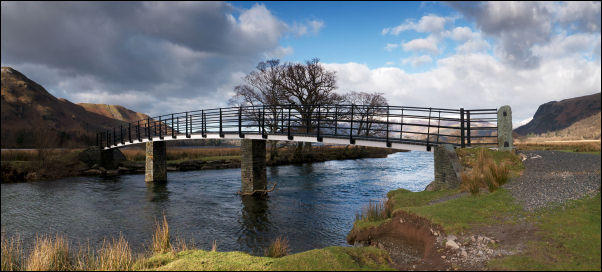
The path east to Watendlath was mostly indistinct but with good visibility I could almost see my objective down by Watendlath Tarn. On my final descent I saw a small tent pitched below Black Waugh. Next to it was something on a tripod which looked like speakers or lights. I was puzzled. I reached the main path and followed it to the footbridge. By the farm building opposite and parked by the road were some large vehicles and people carrying batteries, a reflector and film camera equipment up to the tent area. |
 Watendlath Bridge |
|
|
I spoke to one of the men there who told me they were filming a commercial. It must have been of some importance as there were about 15 people involved, a lot of lighting and even a smoke machine. |
 Film crew at Watendlath |
|
|
I left them to it and took the steep path up towards High Tove. It’s an easy path at first, though steep, but then crosses open fell side which had snow on it to obscure the line of the path for most of its way. The good thing about the zero temperature is that the ground wasn’t as soft and boggy as it usually is. |
 Eddy Grave Stake |
|
|
I made it to the gate at the High Tove summit then turned left to follow the fence north. With no path to follow and snow filling all the hollows the going was difficult all the way to High Seat Summit. As I arrived a couple also reached the top from the other side. We both complained about the wrong weather forecast which had said the sun would be out but all we had was total cloud cover. They set off south and I headed down to the west. |
 High Seat summit |
|
|
After a while there was no path to follow but I just wanted to check out a sheepfold shown on the map. Before I got there I had a look at Pouterhow Pike which is an interesting feature looking more like a mine spoil heap on the fell side. Below it was the sheepfold I was heading for. |
 Descending High Seat |
|
 Sheepfold below Pouterhow Pike |
 The way to go |
|
|
I descended by small streams that all fed in to Thwaitehouse Beck which took me all the way down to the Watendlath Road. I turned north to follow the road for a while before turning left at a cattle grid and following a path down the hillside to a wooden footbridge across Watendlath Beck. |
 Mossmire Coppice |
|
|
There are several paths in the area but I kept to the one through Mossmire Coppice and on down to High Lodore Farm. I rejoined the road and just past the Borrowdale Hotel took the path across fields to the footbridge across the River Derwent. |
 Watendlath Beck |
|
|
Over the bridge the path is raised on duck boards to cross an area which must be impassable at any time of the year. The path just touches the southern tip of Derwent Water at Great Bay before heading through trees to join a track and the road back to Grange-in-Borrowdale. |
 High Lodore |
|
 Last footbridge over the River Derwent |
||
Some useful advice from Christopher Robin as
you walk over the bridge. 'Christopher Robin thought that if he stood on the bottom rail of the bridge and leant over and watched the river slipping slowly away beneath him then he would suddenly know everything that there was to be known' A.A.Milne, The House at Pooh Corner 1928 |
||
 Footbridge over the River Derwent |
 Duck boards across the bog |
|
|
|
||