|
Thirlmere, Birk Side, Helvellyn,
Lower Man, Cumbria. |
|
|
OS Grid Ref:
NY 3161 1730 |
 Charging to park in a lay-bye |
|
The thick cloud didn’t lift so I walked along the forest path towards Wythburn in very dreary and misty weather. It was a mix of forestry track and path and easy going. |
 Drizzle though the pines |
|
Some years ago a lot of pine trees were cut down and now there is a good high level view of the Thirlmere Reservoir Strainer House below. |
 Thirlmere Reservoir Strainer House |
|
Where the track crosses the gulley where higher up are a series of led
mines I came to a memorial bench. The inscription reads “In memory of
Christian and Niggy Townend aged 29 and 21 who died 5 Dec 2010” |
 Memorial bench |
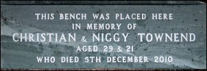 Christian and Nicholas Townend |
|
|
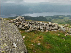
I reached the path signposted to Helvellyn and headed up through the wet trees and gloomy weather. The path is well made with stone steps most of the way. The climb to Birk Side is steady then up ahead I could see that the misty views of Thirlmere would soon vanish. At the old stone ruin I stopped to have an early lunch. It was getting windy so I managed to find some shelter behind a large boulder nearby. |
 Old ruin |
|
Continuing through the mist I reached the saddle above Nethermost Cove which on a good day has great views, but not today. Before reaching the Helvellyn stone shelter wall I saw the small memorial on the right to the landing of an Avro Gosport plane landed in 1926. |
 An Avro Gosport plane landed here in 1926. |
|
I reached the shelter to find a couple of walkers sat sheltering from the wind and eating their sandwiches. I pressed on to the summit trig post then left the path to head south west to find Brownrigg Well. The visibility was only a few metres so I had to use my GPS to keep to the correct line. |
 Helvellyn summit trig post |
|
The well is supposed to be the highest spring in England and it’s the highest I know of. The rate of water flow never seems to vary through the year and is always crystal clear. I headed north to re-join the path and begin the descent. Just past Lower Man I met 3 walkers heading up. We stopped briefly to chat and they asked how far they had to go to the summit. |
 Brownrigg Well |
|
I gave some information about the path and descent route then we continued our separate ways. The descent was steep but mostly of stone steps making it straightforward. I descended below the cloud at 650m and could see the landscape below me. At the bottom of the climb I walked though the main car park to the main road and back to my car. |
 Gloomy descent |
|
|
|
|
|
|