|
Kinlochewe, Loch Maree, Slioch,
Scotland. |
|
|
|
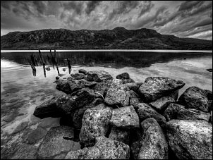 Old jetty on Loch Maree |
|
It was easygoing at first as I walked along the grassy path. A tent was pitched by the fence adjacent to a small well tended graveyard with ruined church. It looked like a back packer with MSR tent. Further on the path vanished into high ferns and I made a wrong turn and had to fight my way through the jungle to rejoin the almost obliterated path. I was soon into open ground again and enjoyed a pleasant walk to the shore of Loch Maree. I took a couple of photos by the remains of an old jetty then continued to the footbridge over the main river coming in from the NE. I left the loch side path to head NE up Gleann Beanaisdail. |
 The path by the river was best |
|
The route to take was a bit confusing as I could see two paths through the heather. I saw a narrow path heading alongside the river so followed that. The map and gps showed the trail higher up the hillside. I’m glad I stayed by the river as there were some nice waterfalls and the recent rain had made them more impressive. Before getting too high I needed to head off to the NW and up to a corrie on Slioch. The map didn’t show a path but I could see a worn path up ahead so I followed it. It is obviously the main ascent route and will have formed through natural usage. |
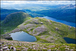
 South view of Loch Maree from Meall Each |
 Tarn with no name at 690m |
|
|
The overcast weather was improving slightly and by the time I’d reached the edge of the corrie there were some patches of sun. On the climb I’d seen a walker with his dog far below but couldn’t see him now. Slioch summit wasn’t visible as it was obscured by intervening high ground. The corrie base was relatively flat for a while then up ahead I saw a steep diagonal path leading up to a saddle. It was an easier climb than appeared at a distance and at the saddle saw a couple of small lochs. Another steep climb was a bit of a scramble in places but still had a good path to follow. The gradient started to ease and I reached a subsidiary summit from where I could see the Slioch summit ahead. There was another small loch as I walked across to it and I was surprised as I reached the summit trig post and surrounding stone wall as it didn’t seem to be the highest point. |
 Looking south on the climb of Slioch |
|
Across to the north was another high point with a cairn. Looking back to the lower summit I’d passed over I saw the walker and his dog approaching. I’d not seen them in the corrie so they must have used an alternative route. The cloudscapes were very impressive but taking pictures wasn’t too easy as the wind was strong and buffeting. Slioch is the western peak of the corrie rim. To the east, along a ridge, is the peak of Sgurr an Tuill Bhain. |
 Slioch summit trig post |
|
Crossing the ridge was interesting due to the cross wind at 25m/s. It was a good excuse to find the occasional bit of shelter and spend a few minutes taking in the incredible vista of endless peaks and huge unseen lochs. The descent down to the corrie bottom wasn’t as obvious as the path so far. The first part was following the gps route on my Garmin but then the visible path left the line on the screen. By the time I’d reached the bottom there was quite a gap. |
 From Slioch summit looking east with big skies |
|
The path wasn’t a problem so I walked over to where the gps said it should be and couldn’t find any trace. I soon reached the route I’d climbed by and picked my way carefully down towards the valley. This time I followed the higher path shown on the map. It took me to the wooden footbridge by the loch side. The 2 or 3 miles back to the car was an easy path through a mix of terrain. The stretches through very tall ferns were even more annoying than when on the way in earlier in the day. Near the burial ground the back-packers tent had gone but they’d left a small pile of un-eaten pasta. Back at the car park I was surprised how few cars there were. |
 Stone art on the descent |
|
|
|