|
Cowshill, Weardale Way,
Coldberry End, Burnhope Reservoir, Co. Durham. |
|
|
OS Grid Ref: NY 8542 4062 |
 River Wear |
|
That’s where any clue to where the path goes ended. I went through the main gate then over a smaller gate and into a wet field. Further on the fields were so wet they were awash. I found a couple of stiles to keep me on track then I eventually emerged onto the minor road by Wearhead Primary School. Along a muddy track I came to occupied buildings then the track deteriorated to almost a muddy river. |
 Wearhead Primary School. |
|
|
 Low Rigg Farm interior |
|
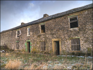
I crossed Burnhope Burn by a footbridge. Then it was across a better field but the path soon headed along the river side and that wasn’t where I wanted to go. I had to cross the field and climb a fence to get to the next minor lane. I crossed over then south up a field towards a farm building on the horizon. The map shows it as Low Rigg and when I got there I saw it had obviously been unoccupied for many years. The roof was still on and most of the rotting windows in place. I looked inside to see that one of the rooms had been used in the recent past as there were two old chairs in front of the empty fireplace, beer cans strewn around the place and a dartboard on the wall. The stars had a carpet on them and upstairs was a room containing a weight training frame. It must have been many years since the farm was fully occupied as the access track was now a very muddy and wet track leading up to Causeway Road. It was even difficult to walk along now. |
 Causeway Road. |
|
I reached the road and hoped that the going would be easier. I was wrong and it turned out to be covered in patchy ice so I had to walk on the snowy verge most of the way. After a mile I reached the gate at the end of the road. A farmer briefly stopped as he passed in his land rover. He asked where I was heading then continued on his way. The forecast high winds now started to increase as I battled my way up the unsurfaced track onto the moors. Another land rover came down the track but he didn’t stop. |
 summit trig post |
|
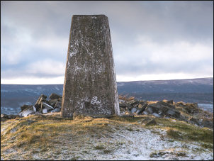
He must have been visiting the shooting hut which is down a side track off the main track over the moor. I reached the gate on Coldberry End then managed to find a deep sink hole to get some shelter while I ate my sandwiches. It was part filled with snow and wasn’t really suitable for a lunch stop. In the absence of any other shelter it had to do. The temperature was below zero and dropping while the wind was getting stronger. I battled my way to the summit trig post and had difficulty taking a picture because of the wind. |
 summit trig post |
|
I struggled though old mine workings back to the track which was even worse to walk on because of a mix of snow and ice. I reached Grass Hill Farm gate then turned NW to Manor Gill buildings. They looked like stables inside and were in reasonable condition so gave me some brief shelter from the wind. The map shows a track heading towards Langtae Head Quarry. There was hardly any sign of it and it was very wet over most of its length. The quarry area was just a wasteland and not a quarry in the conventional sense. By now it was snowing and I was walking in a whiteout blizzard. |
 Manor Gill buildings |
|
The track across Burnhope Moor was reasonable to follow and because I’d changed direction I had the wind behind me. The snow stopped as I descended the track by Todd Syke. The track improved and had even been stoned. Down at Burnhope Burn there was a substantial stone shooting hut that wasn’t shown on the map. It must have been built relatively recently. I crossed the river by the vehicle bridge with the intention of following the track along the north side of Burnhope Reservoir. |
 Storm damage |
|
When I got there I changed my mind and followed the track back down over the river to follow the track through the pinewoods on the south side. I soon had to detour round some fallen trees caused by recent wind damage. Along the track I came to the reservoir embankment but the gate was locked. |
 Storm damage close up |
|
|
 Burnhope Reservoir |
|
It was
an easy climb up the wall to walk round the fence by the road then
across the dam. At the north end a stone plaque reads: |
 Burnhope Reservoir memorial |
|
I followed the road for a while then down a rough path to the farm buildings of Blackcleugh. The map shows them as a possible Youth Hostel but they had all been deserted for many years. Across a field I rejoined the road and an easy walk back to Cowshill and the car. |
 Blackcleugh |
|
|
|