|
Swaledale, Maiden Castle,
Harkerside Moor, Apedale, North Yorkshire.
[17.3 km]
Wed 24 Sep 2014 |
|
|
|
OS Grid Ref: SE 02022 98265
Lat/Long: +54.379881, -01.970375
I drove to the start of the walk in Swaledale via Wensleydale and the
narrow connecting road over The Fleak. It was quite rough in places and
good to traverse on a bike but not to drive in a car. However, the
mostly clear weather made for lovely views of Swaledale as I descended
to the small car park between Low Whita and Grinton. |
|
|
|
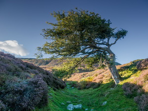
Approaching Swaledale from The Fleak |
|
|
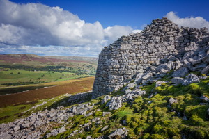
My first objective
was the feature shown on the map as ‘Maiden Castle’. It was also the
first outing for my new Zamberlan boots so the other objective was to
start breaking them in. It was a short climb up from the road and a
large earthwork structure that doesn’t have any definitive conclusion
about what it was. It’s a roughly circular earthwork with a stone rubble
avenue at the east side. It has been described as a settlement or fort
dating from around 600BC. After walking along the ditch I climbed up
through the heather and soon came to a path running east. |
|
|
It was level
for a while then began to descend to a path junction that I followed to
the right. It climbed up to a large stony area then joined a substantial
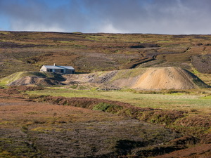
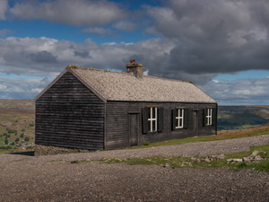
track that I followed up Grovebeck Gill. In the distance I could see a
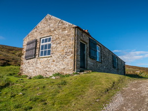
large mine spoil heap and impressive shooting hut. It was an easy walk
to get there and I was surprised to find that the shooting hut was
unlocked. |
|
|
|
Approaching Grovebeck workings |
|
|
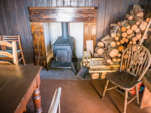
Inside were two large rooms with large tables and chairs. An
open fire was at one end and a large stock of chopped wood. The overall
condition of the hut was excellent and one of the nicest interiors I’ve
seen. I left and continued along the vehicle track to the east. In just
under a mile I reached the Grinton to Redmire Road. |
|
|
|
|
|
I turned right and
followed it up to a stream crossing underneath and a path sign pointing
up to the right. I left the road and followed the path. It was
indistinct at first but soon became more substantial as it climbed up
through the old workings of Grinton How Lead Mines. It was pleasant walk
up to the Greets Hill summit and two summit cairns. There was now
another vehicle track to follow for the descent and a series of well
made circular stone shooting butts. The descent took me down to Apedale
to a collection of huts called Dent’s Houses. Another track ran up west
up Apedale. It was an impressive walk up the valley and the whole area
was filled with old abandoned mine workings and spoil heaps. At one
point I came across and old mine heading down below the track. |
|
|
|
|
|
The
steady climb became steeper as I reached the summit and a gated fence.
The gate catch wasn’t working so someone had put rocks against it to
keep it shut. It was here that I met my first walker of the day, a man
coming up from Swaledale. I descended to the area called Morley’s Folly
but couldn’t see what the folly could have been. The track continued
straight on but I wanted to follow a path off to the right that is shown
on the map. There was no sign on the ground but as I continued through
rough ground a faint path appeared. Eventually it joined another vehicle
track that was only partly shown on the map. I soon reached a
substantial lime kiln by the track and had a walk round it to inspect it
from all sides. It’s location above Swaledale was very impressive. The
odd thing was it wasn’t shown on the 25K map I had with me. But it is
shown on the large scale 10K map. |
|
|
After crossing Browna
Gill the track reached another wonderful shooting hut. It was also
unlocked and had an equally impressive interior with tables, chairs and
large pile of cut wood by the fire. |
|
|
I left to continue but soon came to the branch left
and a steep descent down towards the road. I still had impressive view
as I descended then as I began to wonder how far I had to go to re-join
the road I rounded a bend to see my car just a short way ahead. Mine was
still the only car in the car park. |
|
|
|