|
Embsay, Embsay Moor, Upper
Barden Reservoir, Yorkshire. |
|||||||
|
OS Grid Ref: SE 00963
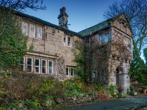
53844 The free car park in Embsay, near Skipton, was ideal for the start of my walk. I walked over Embsay Moor some years ago while on a backpacking trip so today decided to have another look from a different approach. I left the car park and headed west along Pasture Road. I was intrigued by an old mill chimney down to my left and some refurbished buildings which could have been some of the original mill buildings. |
|
||||||
|
The site was the Primrose Cotton Mill. On my right was the old Manor House, I think the date stone said 1665. The lane reached Embsay Reservoir which was completed in 1909 as a water supply for the Skipton area. Below the dam I could see an old mill chimney. The old Ordnance Survey map shows it to be the site of the Good Intent Cotton Mill (Crown Spindle Works). |
|
||||||
|
Across the reservoir was the impressive and distinctive Embsay Crag. At Crag Nook I crossed a wooden stile to walk a short way along the track to try and find another minor track heading north onto the moors. I reached the point shown on the map but there was no track to be seen. I headed over rough ground to climb up to the Deer Gallows rocky outcrop. |
|
||||||
|
|
||||||
|
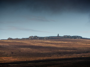
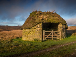
It was an interesting viewpoint but the previously clear weather kept clouding over. I managed to find the track I was looking for and headed over East Harts Hill where I got a good view of the distant obelisk on Cracoe Fell. I wasn’t going that far so continued along the track to an interesting shooting hut with earth roof and open front. |
|
||||||
|
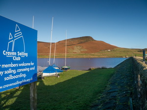
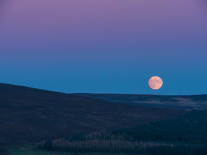
Continuing along the track I came to a view of the Upper Barden Reservoir below. I descended to the dam for a look. The map says it was for the Bradford Corporation Waterworks a net search says it was built in the 1880s. I followed a path to the SE across Lumb Gill Wham which turned out to be the line of an old narrow gauge railway used in the construction of the reservoir. Eventually I reached Barden Road and turned right. I stopped briefly to watch the almost full moon rising. I walked back through Eastby and back to Embsay. I set off on the walk just after 2pm, it was dark when I got back to the car. |
|
||||||
|
|
|||||||