|
Falls of Cruachan, Cruachan
Reservoir, Ben Cruachan, Stob Diamh, Scotland.
[15.6 km]
Thu 30 Jul 2015 |
|
|
|
OS Grid Ref: NN 08064
26700
Lat/Long: 56.393462, -05.111237
I’d had a good night’s sleep in the lay
bye by the Cruachan Falls Railway Station. Because I was already on-site
for the start of the walk I was on my way at 06:10am. The climb up
through the trees starts off by passing under the railway but I had a
quick look at the picturesque railway platform before continuing up. The
undergrowth was very dense and over my head for a lot of the way. I was
last here in 2010 when the weather was wet and raining. |
|
|
|
Falls of
Cruachan Rail Platform |
|
|
It was clear at first but
clouds rolled in later but thankfully didn’t bring any rain with them. I
reached a tall deer fence and climbed over the tall and very rickety
ladder stile. I reached the base of the Cruachan Reservoir Dam and
followed a line of steps up to an almost vertical ladder that I climbed
on to the top of the dam. |
|
|
|
|
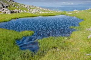
The access track along
the west side of the reservoir was easy to follow and very pleasant
walking. Almost too pleasant as I missed the stone cairn marking the
point where the path heads up to Coire Dearg. I soon realised my mistake
and returned to start the climb. It was steady going and only became
steep on the final push to the saddle where a small tarn, or is it
lochane, appeared blue in a short period of sunshine. |
|
|
|
|
|
|
Near the
summit of Ben Cruachan |
|
|
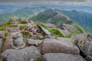
I turned right and
followed the rocky path up the south slope of Ben Cruachan. It now felt
quite cold and on the last push to the summit the temperature dropped
from 4degC to 3degC. I was great reaching the summit and having a good
view. I’d taken a photo on my phone on the way up and posted it to
Facebook. There was a slow data signal so it took over 10 minutes to
upload the one photo. There was the stump of a broken Ordnance Survey
post which was one of the cylindrical concrete type. |
|
|
I continued my walk along
the ridge which started with a scrambley descent down through the rocks.
The temperature dropped even further to just above freezing at 1.5degC.
I came to the large slab along the ridge and started to climb it. It was
quite exposed and not being able to see what was ahead decided to take
the safer route by descending for a while and following a narrow path
below the rocks. The climb back to the ridge was easy so I’d made the
right decision. |
|
|
|
Ben
Cruachan summit and trig post |
|
|
The rest of the horseshoe
ridge was up and down but fairly easy. Some cloud had blown in for a
while to obscure Ben Cruachan but it soon cleared. The rest of the cloud
stayed high enough not to obscure my views. I started my final descent
to the reservoir by following a path shown on an on-line map. I hadn’t
gone far when I realised there was no path of any kind on the ground so
I had to traverse the mountainside to find a less steep route. There was
no defined path to follow until I reached the wet path just above the
reservoir. |
|
|
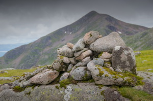
|
cairn
view back to Cruachan |
|
|
It reached an access
track where one of the tunnels discharges water into the reservoir. This
one collects water from intakes on the other side of the mountain. I
reached the dam and continued my descent down the access road for a
while. Then I picked up my ascent route and descended back over the
rickety ladder stile and down through the woods to my car in the
lay-bye. It was the only the car there when I left but now it was full. |
|
|
|