|
Edmundbyers, Pedam's Oak,
Belmount, Horseshoe Hill, Edmondbyers Cross base,
Muggleswick Common, Co Durham.
[21.9 km]
Wed 12 Aug 2015 |
|
|
|
OS Grid Ref: NZ 01340
49744
Lat/Long: 54.842509, -01.980657
I drove via Barnard Castle and Stanhope
over the picturesque moors to Edmundbyers where I parked by the village
name sign.
My walk started along a stony track which was soon a very wet track.
Further on I had to follow a path through deep and very sharp gorse. I
was glad to emerge along a clear track to Swandale Cottage. |
|
|
I joined a good stoned
track which headed out into the distance. I could see a vehicle ahead
towing a trailer which seemed to be loaded with timber, presumably fence
posts. I passed a small deserted building called Swandale Cottage then a
more substantial ruined farm called College. |
|
|
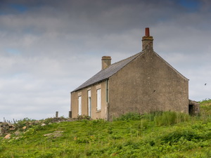
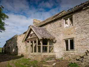
I was then on a more
level farm track for about a mile to another deserted farm called
Pedam’s Oak. It had been empty for many years but most of the roof was
still intact with a very dilapidated interior. A large timber porch
protected the front door and this must have been a very substantial farm
in its day. |
|
|
|
|
|
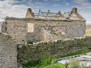
I continued along the
track towards the ruin of Belmount Farm that I visited on my walk last
week. I could see the truck and trailer that I’d seen earlier parked on
the west side of the buildings. As I approached I could see that what I
had thought were wooden fence posts were beehives. Two men in protective
suits had set the hives up and suggested I didn’t get too close without
protection as the bees were flying around and rather annoyed at having
been transported there. |
|
|
|
|
|
They said they’d brought
the bees here for the heather which would produce a high quality honey
for about 6 weeks. As suggested I didn’t get too close. I continued
along the farm track to the road at Near Sandyford then turned south and
walked along the road. It was pleasant walking as there was little
traffic. Up ahead I could see a radio mast on the summit of Horseshoe
Hill. |
|
|
I was paying too much
attention to the route I would take to walk to the summit and not enough
attention to my next objective which was Dead Friar’s Stone. By the time
I’d realised I should have looked for the stone I’d walked over a
kilometre past its location. It was too far to walk back so I continued
and decided to search it out on my drive home. |
|
|
|
|
|
The map shows a path
running diagonally up Horseshoe Hill and there is ever a wooden path
marker by the road. Unfortunately the path that may have been there at
one time has long since grown over and there is no sign now. I continued
along the road and took the best route I could find up to the mast
access road. To the east of the mast I visited the Ordnance Survey trig
post then returned to the mast access road and back to the road. |
|
I continued along the
road to the sharp left turn to the road heading back to Edmundbyers. I
saw a stone boundary post on the left then continued to find
Edmondbyer’s Cross remains. This is the spelling on the map but it can
also be spelt Edmundbyer’s. I’d found its co-ordinates and used them to
try and find it. The co-ordinates were wrong and I found the cross base
about 50m to the west. |
|
|
It is large and
impressive. I continued north along the road then turned off to the
right to follow a minor track across Muggleswick Common to the trig post
on Stoterly Hill. There were impressive views all around. I followed the
path to Lamb Shield Farm where I descended by the farm’s access track to
the road at East Cot House. It was then a short walk back to Burnhope
Bridge and my car. |
|
|
|