|
Stainmore, Moudy Mea Mast, Roman
Signal Station (Roper Castle), Summit Reservoir, Stainmore Summit
railway route, Cumbria.. |
|
|
OS Grid ref:
NY 87130 12909 Lat/Long: 54.511321, -02.200290 The drive to the start of my walk did not go to plan. I had a good drive up the M6 and left at Tebay then through Brough and east on the A66. The turn off after Stainmore turned out to be blocked off due to resurfacing works. As the A66 was down to one lane I had to drive another 4 miles east to turn around and return all the way to Burgh. Here I was able to pick up the diversion signs and return through the lanes to the start of my walk. |
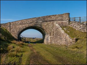
 Boundary on the bridge |
| I started by heading west along the road which was the old abandoned length of A66. Descending a minor lane to Blackhause Syke I passed an interesting boundary stone on the stone bridge. Up the hill I crossed the bridge over the old abandoned railway. Further on I left the road and headed east up a rough track and on to the moors to Moudy Mea and a transmitter mast. |
 Line of abandoned railway |
| As I reached the mast there was a vehicle parked outside, presumably belonging to an engineer. The access gate to the mast buildings was open and someone was obviously working inside. I left the mast and headed across open moor where there is no path shown but I found the going relatively easy. In the distance was a boundary wall and fortunately a gate to get through it. |
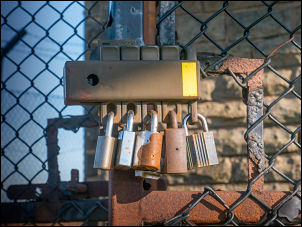 Moudy Mea multiple locks |
 Moudy Mea mast |
 Moudy Mea mast |
 Roman Signal Station |
|
| My first objective was to investigate a feature on the map described as a Roman Signal Station, also Roper Castle and Round Table. I eventually saw it in the distance and when I arrived it was obviously a man-made ditch structure of some age. It didn't seem likely to be a signal station because it wasn't quite at the highest point. |
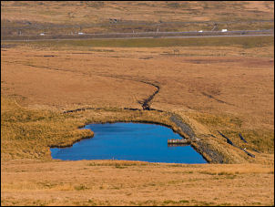 Summit Reservoir |
| I stopped here in the pleasant sunshine to have my sandwiches then descended to the north through rougher ground down to a feature called Summit Reservoir. It seemed out of place in the landscape as there are no villages or towns nearby. However my suspicions that it was connected with the railway were proved correct. |
 Summit Reservoir |
 Stainmore Summit today and back in 1972 (I copied the old photo but don't know who the author was). |
|
| The reservoir was held back by an earth embankment where some subsistence had occurred in the past. I descended the outlet stream down to the line of the old Penrith Darlington railway which closed in 1962. The line of the railway is still very obvious as it is in cutting. However it is very wet and needed constant crossing of the route. The original summit sign is still there and it can also be seen from the A66 Road. |
 Pill Box above the railway |
 Pill Box above the railway |
 Pill Box above the railway |
| The area does not show any signs of a railway having been there. It is difficult to imagine that several lines of track used to run over the summit. I continued along the route and joined a length of road before leaving it to re-join the grass covered line of the railway route. The views were exceptional and I enjoyed the walk all the way back to the road where I'd originally crossed the railway bridge. Here I re-joined the road and walked back to the car. |
 Rejoining the road |
|
|
|