|
Cawdale Slate Mine, Loadpot
Hill, Helton Fell, Heltondale Beck, Cumbria |
|
|
OS Grid ref:
NY 49814 18331 Lat/Long: 54.557711, -02.777527 The start of today’s walk is above Brampton where I was last week. Because the access road from Shap is closed for road works I continued to Penrith and dove back through Askham and up the narrow lane towards Moorahill Farm. There are no parking areas but some wide verges. I parked at a spot I’ve used a couple of times before and set off west along the lane towards Kowtop Kirk. |
 Cawdale valley. |
| The weather was overcast and felt quite cold. I soon left the road to follow a path I hadn’t noticed before. I took me directly to the stone slab footbridge across Cawdale Beck. I passed the circular Kowtop Kirk earthwork to my left then left the path to head up Cawdale valley. There is a lot of boggy ground on the valley floor so I kept to a higher contour to my left. I crossed a large area of landslip then continued left to where the valley narrows. |
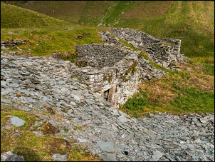 Cawdale Slate Mine |
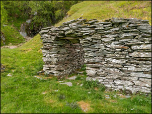
 Mine entrance |
 Mine interior |
| I was now on the old access track to the Cawdale Slate Mine. The main access track was along the north side of Cawdale Beck and would have involved wading across the river. I continued up the track and came to a small ruined hut. Further on were the slate spoil heaps and several ruined buildings. I investigated a tunnel entrance which was open with no restrictions to the access, though I certainly didn’t fancy going in as it was partially flooded. Further up the valley was a large but shallow cave entrance which I’d visited on a previous occasion. |
 Cawdale Slate Mine |
| There had been a landslip from above which had partly fileld the valley bottom. After climbing steeply up I came to a zig zag track which headed up to the fells. I was above Atkinson’s Grain and eventually crossed it higher up to head for Wether Hill and join the main High Street path. I then had a full, but hazy, view of the fells to the west. I headed north to the site of Lowther House. It was originally a shooting lodge of timber construction with stable attached. The chimney stack has long since collapsed but there is a nice sketch of it in Wainwright’s ‘Far Eastern Fells’ guide book. |
 Lowther House Shooting Lodge from Wainwrights book |
 All that's left of Lowther House Shooting Lodge |
|
| The remaining parts of the floor were of concrete so it probably wasn’t of a great age. A short way to the north I came to the Loadpot Hill trig post. As I descended to the north I was four figures approaching. Two young men were in the lead and they were carrying something between them. As I got closer I saw that it was rucksack, each holding one of the straps. They both had their packs on. Behind were two young ladies but only one carrying her pack. The other was having hers carried by the gallant young men. |
 Loadpot Hill trig post |
 Distant view of Helvellyn |
|
| I left the main path at Wartches and headed for Helton Fell. It was pleasant walk and over Helton Fell had good views but no paths. I descended to the road and the access road to Scalegate farm where a couple of dogs barked constantly as I approached. |
 Passing Scales Farm |
| I then reached Scales Farm with an interesting date stone over the door. The owner had painted it all black so the text was hard to read. It reads Thos & Ann Dufton 1763 but the letter D is the wrong way round. I followed the rough lane down to Heltondale Beck and the stone packhorse bridge. |
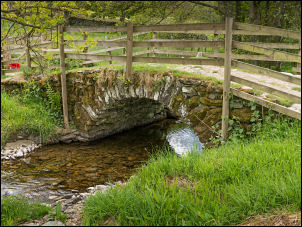 Heltondale packhorse bridge |
| The last time I was here there were no handrails but now timber posts and rails have been fitted. Frther up the fell was a large sign saying “Bridleway and Footpath go through the Gate and turn left.” |
 Helping the walker |
| Which leaves the walker in no doubt. Continuing up the fell I reached another path which I followed back to the road at Cockle Hill and what must be one of the most remote post boxes in Cumbria. It is fixed in a wall with no properties nearby. I was back on the adopted road but had to pass through 4 gates before reaching my car. |
 Remote post box |
|
|
|