|
Weasdale, Hooksey, Randygill
Top, Green Bell, Cumbria. |
|
|
OS Grid ref:
NY 69319 03838 Lat/Long: 54.429033, -02.474431 The weather was overcast and a bit rainy as I drove north on the A6 to leave at Tebay. It didn’t take long to reach Weasdale which on the northern end of the Howgill Fells. I left my car on a small hardstanding by the road and started walking along the lane. I was here last in November 2005 and today I’m using the gpx track I recorded then as a guide. |
|
 Nov 2005 |
 June 2016 |
| A walked past a collection of buildings then up to the end of the narrow lane to Cow Bank which is a building that was being renovated in 2005 and still seem to be having work done on it. I didn’t see any evidence of anyone living there but there was a barking dog at the back. On the wall is a modern date stone saying David & Angela Jackson 2003. |
 |
| I turned left to head south along a rough farm track that soon vanished. I headed gently up the ridge of Hooksey which is a public footpath but there is little sign of it having much use. There was low cloud but I had nice views down into Weasdale to my left. |
 |
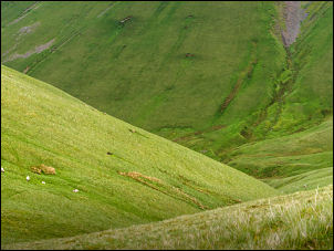
| Over the unmarked summit I walked steeply down to the saddle at Leathgill Bridge, which isn’t a bridge. Straight ahead I could see a faint path heading up to Randygill Top which has a fairly large cairn. I was now able to get some good views and as I headed NE towards Green Bell I could see Yarlside to the south and down into the valley with ‘Mountain View’ farm. I visited it some years ago when it was an intact building. It had been one of the filming locations for the 1998 film ‘B.Monkey’ I don’t think the building has been occupied since then. I visited it in Apr 2009 and the roof was starting to deteriorate then. |
 Looking down to Mountain View |
| Looking down on it today the roof had now collapsed in. I continued towards the mist that was obscuring Green Bell but as I started the final climb I could see the trig post through clearing mist. |
 |
| There was still no sign of anybody so I continued my way to the north and the descent towards Hunthoot Pike. I was on the official path part of the way then left it to get better views down into Great Swindale. Eventually I came to a rough track that took me to Pinksey Head then back down to the road at Weasdale. |
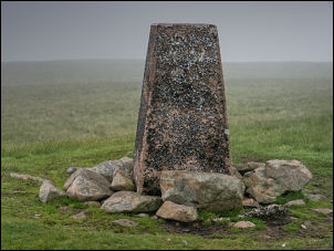 Green Bell summit trig post |
|
|
|