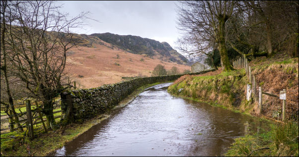
Swindale flooding. |
|
I set off south along the lane by Swindale Beck. I hadn’t been
going long before I came to a flood across the road. It was
quite deep so had to traverse the adjacent fence above water
level. I reached the Water intake weir then further on the
footbridge over Swindale Beck. The far side was waterlogged
after the recent heavy rain. |

Access to the footbridge. |
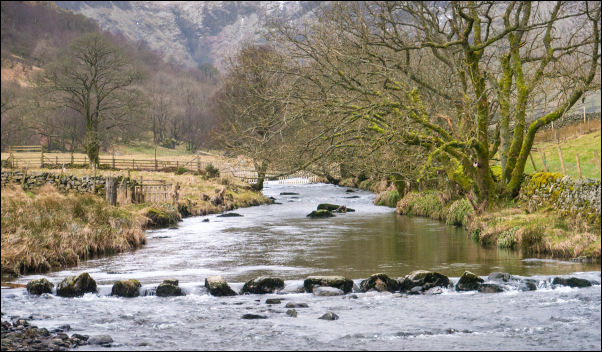
Swindale beck and the stepping stones. |
|
I soon reached the stepping stones which were above the water
level but not a way I’d like to take. I headed up the wet
hillside towards Gouther Crag. Higher up the indistinct track
became a sunken track. It was easy going and I continued
steadily upwards to the waterfall at Haskew Beck. Because of
lots of recent rain I was concerned about how wet the fells
would be. The official path goes through some very wet ground as
I found out on my last visit in summer 2 years ago. I decided to
keep to the right and follow higher ground. |

The stepping stones. |
Kidsty Pike in the distance. |
|
My diversion turned out to be a good choice. There were some
shallow snowfields but generally I was able to avoid the worst
of the wet ground. Eventually I reached Seat Robert and the
large cairn with adjacent stone shelter. It was windy and a
temperature of -2degC so I checked the shelter. It was
ineffective. Slightly to the south was the Ordnance Survey trig
point. It’s not shown on the maps and isn’t a traditional
column. A concrete ring marks a copper pin set in the rock. |

Seat Robert cairn & OS trig point. |
|
My diversion turned out to be a good choice. There were some
shallow snowfields but generally I was able to avoid the worst
of the wet ground. Eventually I reached Seat Robert and the
large cairn with adjacent stone shelter. It was windy and a
temperature of -2degC so I checked the shelter. It was
ineffective. Slightly to the south was the Ordnance Survey trig
point. It’s not shown on the maps and isn’t a traditional
column. A concrete ring marks a copper pin set in the rock. |

The OS copper dome pin trig point
and
concrete ring marker. |

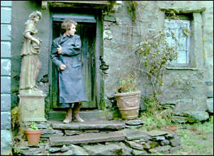
Approaching Sleddale Hall with Wet Sleddale Reservoir
behind. |

Sleddale Hall. |
|
I took a photo and left to the SE. I managed to find a bit of
shelter by a snowdrift and used it to eat my sandwich. The
second objective was to cross the route across a stone wall and
on to descend to the track from the old quarries to then to
Sleddale Hall. I stopped to look at the hall and it was just the
same as the last time I visited 2 years ago with no evidence of
more building work having been done. It was the location of some
filming for the 1987 film ‘Withnail and I’. |

Sleddale Hall kitchen door. |
Kitchen door in 'Withnail and I' |
|
I followed the track down to Sleddale Grange then left through
the farm gate to follow the very muddy track to the next gate.
The path down to the road was extremely wet and I was glad to
reach tarmac on the Water Company road which is private to
vehicles. I continued NW and when I reached the junction to
Tailbert decided to carry straight on. My original plan was to
continue to Tailbert then descend the fell side to the bridge
and back via Swindale Foot. |

A great sign on the road while walking back. |
|
That part is a walk better done on a fine day so I continued on
the tarmac to the road bridge over Swindale Beck then left up
the wet hillside to join the Swindale Road. It was a short walk
back to my car. |