|
|
OS Grid ref: SD 63462 11882
Lat/Long: 53.6022150, -2.5536220
|
Before setting off f. |
|
Lockdown 02 starts today. Caught the 09:30 bus from Shaw Hill
and rode via Chorley to Horwich and ‘The Crown’ stop. I set off
along Lever Park Ave and stopped to photograph the entrance
pillars. |
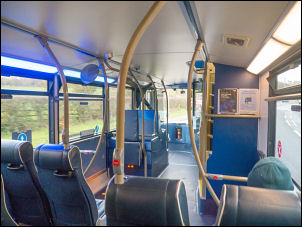
On the bus to Horwich. |

LEVER PARK
These Pylons were erected by William Hulme 2nd
Viscount Leverhulme to commemorate the gift of Lever park by his
father 1934.
|
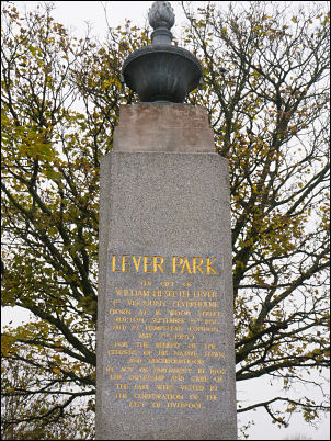
LEVER PARK
The gift of William
Hesketh Lever 1st Viscount Leverhulme (born at 16 Wood Street
Bolton September 19th 1851 died at Hampstead London May 7th
1925) For the benefit of the Citizens of this native town and
neighbourhood by act of parliament in 1902 the ownership and
care of the park were vested in the Corporation of the City of
Liverpool. |
|
Approaching the Grammar School I turned right up Roynton Road
which deteriorated as I continued. At the elft bend I took the
right branch up towards the farm but soon left if to head right
into Shaw’s Wood. For a while there was a good path but after a
while it started to deteriorate as I followed the bank of the
River Douglas. The path left the valley and headed north on a
wet route but mostly open ground. As I reached the Belmont Road
estate track I could see the ruins of Prospect Farm at the base
of the bank. |
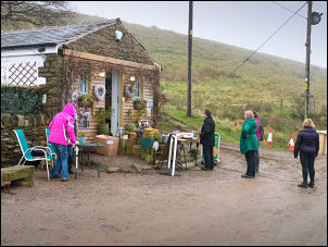
Snack Shack queue. |
|
On the track I turned right to the Rivington Pike Snack
Shack building which was doing a good trade as people queued
outside exercising social distancing. The adjacent building used
to be the Sportsman’s Arms but its license was transferred to
the Bridge Inn, Horwich in 1876. The weather wasn’t good and aas
I took the path north towards ‘Two Lads’ cairns I was in the
mist and that would be the last of my views for the day. The
moor wasn’t as wet as I was expecting and it didn’t take long to
reach the main cairn ‘Two Lads’ and two nearby smaller cairns. |
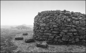
Two Lads main cairn. |
With the mist there was nothing to see so I continued to the
access road to the main transmission masts on Winter Hill. There
were a few people around as I walked up to the main buildings.
When I got there I sheltered from the wind behind the building
to eat one of my sandwiches. |

Not much to see. |
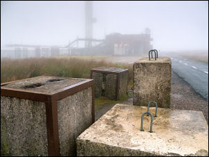
Approaching the Transmission Mast buildings |
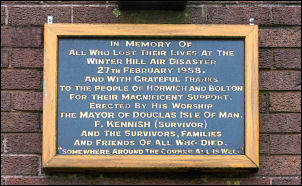
The Winter Hill air disaster of 27
February 1958. A plane flying from the Isle of Man to Manchester
crashed into Winter Hill. Thirty-five people died and seven were
injured. |
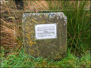
In memory of George Henderson, murdered 182 years ago
today (9th Nov 1838) on Winter Hill. A memorial ‘Scotchman's
Post’ marks the spot adjacent to the Winter Hill transmission
mast buildings.
Newspapers reported that he was shot through
the head by some villain and his pockets rifled after which the
body was thrown into a ditch by the road side. |

Scotchman's Post. |
I continued to the trig post which was difficult to get
to because of horribly wet ground around it. I took my time on
the steep descent path towards Hordern Stoops. At the bottom of
the bank the route roughly follows the wall but was so wet I
tried to walk on the collapsed wall as far as I could. Once off
the wall it was more like wading than walking. |

Winter Hill trig post. |
At the road I stopped to eat my second sandwich before
continuing north over Will Narr and along Spitlers Edge.
This stone marks the source of the Yarrow and commemorates the
10th anniversary of Friends of the River Yarrow (FRY) Unveiled
by chairman Michael Callery OBE 2011.
[www.friendsoftheriveryarrow.co.uk]
The website no longer
exists.
|
Yarrow source. |

Very wet Spittlers Edge. |
|
I still couldn't see much and even the stone slabs only gave
some respite from the wet as many were partly underwater. At
Great Hill there were quite a few people so I didn’t stop.
Descending to the ruins of Drinkwaters I had an atmospheric view
of the ruins. The mist had turned to drizzle and even when I
reached White Coppice it was still misty. The rest of my way
home was along the road through the drizzle. |

Ruins of Drinkwaters Farm below Great Hill. |
|
|
|
|
|
|
|
|
|