|
|
OS Grid ref: NY 33785 26627
Lat/Long: 54.630414, -03.027212
|
It was an extremely gloomy dark drive along the M6. The windsock
that I could see last week at Tebay was lost in the gloom. I
reached the layby near Scales and set off to walk up Blencathra
via Doddick Fell Ridge. It's a route I've never done before. As
I drove along the A66 I couldn't see any of the mountains as
they were all lost in cloud.
|

Path above Doddick Farm. |

Scaley Beck. |
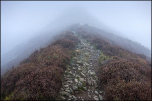
Doddick Fell Ridge |
|
By Scales Farm I followed the track up to a gate then joined a
narrow path heading west. At Scaley Beck the path was rather
scrambly as there was a steep slope down to the water. Once
across I had another scramble up the other side. It wasn't long
before I came to the right branch to start the climb up the
ridge. It wasn’t long before I reached the low cloud and then
plodded steadily upwards with little to see other than the path
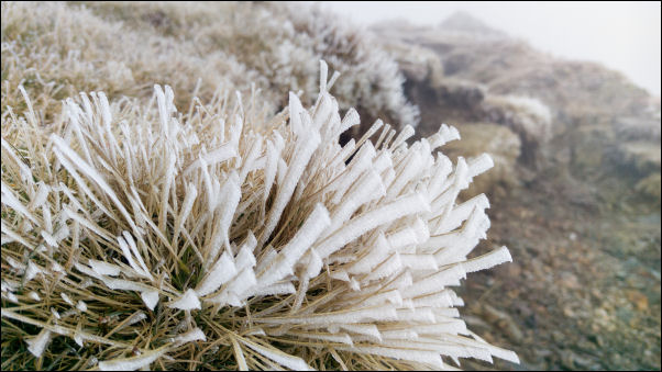
in front. The temperature was soon below zero and the ground
frozen hard. My concern was ice on the rocks. There were no
particular problems on the climb and I hope to return in better
weather. At the top of the ridge I reached the main track up to
Blencathra which I joined. |
|
|
Near the top of Doddick Fell Ridge. |

Blencathra Trig Point. |
|
Following the zig zag I reached the final flat stretch of path
to the summit trig point ring. There was a solo man standing
there eating some food. The view was thick mist at -3degC and
little wind. I didn’t stop but turned right to head north to
Atkinson Pike. The small tarn was iced over as Ii passed. On
Atkinson Pike I took the left branch of the path to start the
descent. Straight on was the way down via Sharp Edge, definitely
not a way to go today. I continued my descent but had to take
extra care as the ground was frozen hard and icy in places. |

Frozen tarn. |

Cross of stones. |
|
Eventually I approached the pass at Mungrisdale common with a
temperature above zero and no icy patches. I turned right to
descend above the river Glenderamackin. Lower down the weather
cleared a bit and I was able to see the valley. I met the second
walker of the day as he came up. He asked about the view on the
summit and I said there wasn't one. |
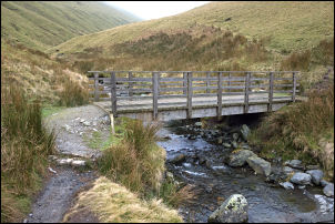
Wooden footbridge. |

View towards Matterdale Common. |
|
I crossed the wooden footbridge and started to climb to the
right when I met another walker. He stopped to ask if he was on
the right way to Mungrisdale Common. I said he was and we
chatted a while about walking in the area. Over the ridge I
descended the easy path down Mousethwaite Comb and almost missed
the branch path to take me back to Scales. After a short climb
and minor path I reached the White Horse Inn then back to my car
where the weather was clearing. |
|
|
|
|
|
|
|