|
|
Lat/Long: 53.955150, -02.559923
OS Grid ref: SD 63262 51173
|
|
|
|
A dark drive via Longridge to Langden in the Trough of Bowland.
It was just coming light as I arrived at the parking area by the
Langden Intake access road. I set off west along the avenue of
trees with autumnal colours until I came to the Keepers House. |
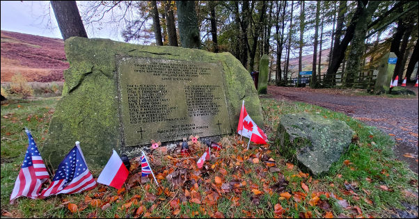
Memorial at the Langden entrance. |
|
It is no longer occupied but seems to have escaped the vandals
even though the access gate is unlocked. I took a few photos
then continued up the track by the perimeter fence and bushes.
Peering through the trees I could just see the water nymph
statue ‘Miranda’ in the distance. Further along the track was
was an information board about the area and also mentioning
Miranda. |

Langden Intake House. |

Miranda. |

Miranda. |

Miranda. |
|
I climbed over a wooden gate and walked down to the intake
perimeter fence. There was a small gate at the west end which
was unlocked. There was no ‘keep out’ sign so I went through to
have a closer look at Miranda and take a few photos. I returned
to the track and continued up the valley. The next stop was at
the Langden Borehole building which stands alone with just the
power cables connecting it via overhead poles. There is no sign
indicating what it is. |

Langden Borehole. |

Memorial above Langden. |
Continuing above Langden Brook came to a stone tablet memorial
to Pilots killed on the moors during WW2. It wasn’t here the
last time I visited. The inscriptions are:
==
In Memory Of
P/O N J Sharpe
Royal Air Force
crashed 18/8/1941
Hawthornthwaite Fell
F/O W Pucek
Polish Air Force
crashed 28/12/1942
White Moss Fell
F/O S P Marlatt
Royal Canadian Air Force
Crashed 29/11/1942
Holdron Moss
Rest in Peace
== |

Langden Castle Bothy. |

Ford across Fiendsdale Brook. |
|
As I continued I noticed the bothy called Langden Castle on the
map. I expect many walkers will have reached it and been
disappointed that it isn’t a castle and is also locked. When I
got there I had an important decision to make. My planned route
was south along Bleadale Water but recent rains had lifted the
river levels and I had to river crossings, with no bridge! I
knew I’d have to wade but wasn’t sure about the water depth and
speed. There was an alternative longer route via Fiendsdale Head
but that was a last resort. I prodded my walking pole into
Fiendsdale Water and found it not too deep. With boots off and
my wading socks on I set off across and reached the far side
without difficulty. I kep my socks on as I then had to cross
Bleadale Water. These 2 rivers combine a short was downstream to
for Langden Brook. With my boots back on I continued south along
a path on the east side of the valley. I was pleased that it was
easy to follow and continued up to a fork where the official
path stayed with the river while I took the left branch to head
up a track towards the Hareden Fell top. |

Above Bleadale Water. |

Crossing Whitmore Fell. |
|
It was an easy track but once I reached the high area by the
shooting butts the it petered out. There was no track along the
fell top but the ground was surprisingly essay going. I headed
south towards the main path along the watershed. On the way I
crossed an area called David’s Tomb on the map but there is no
evidence of anything on the ground. The easy going ended when I
reached the watershed fence. I turned left to head towards
Totridge trig Post but the ground was horribly broken up with
hags, bogs and tussocky ground. I had to take many detours to
get around the many obstructions. |

Totridge Trig Post. |
I reached a stone wall at the top of Whitmore Fell and found the
going a bit easier until I reached Totridge summit. The weather
was good and I had some nice views. At the trig post I noticed a
plaque reading:
Bill Smith (1936-2011) Fell Running legend
died on these Hills.
https://en.wikipedia.org/wiki/Bill_Smith_(fell_runner) |

Bill Smith (1936 - 2011) Fell running legend died on these
hills. |

New Hey Farm. |
|
I then began my descent by heading down the east side of the
fell. I reached the wall and followed it carefully down as the
gradient was very steep. At the area with the wonderfully names
Pether Stake I took a diagonal route to avoid areas of rushes
until I reached more level ground. Over the fence I reached the
old track at the base of the fell and also the public footpath.
To the north I reached the flat area that used to be the site of
New Hey Farm. There is nothing to reveal it ever existed. The
1851 map calls it New Hey and below and across Red Syke is New
barn. |
|
By 1914 it is called Old Hey and the barn is called New Hey. I
followed the track down and across to New Hey which has been
renovated and extended. The main house is very large and the
barn behind has been converted to a dwelling. The owner wasn’t
there but a workman was doing some building work nearby. I told
him about the 1874 ‘Diabolical Outrage’ article and left a
printout for him to hand to the owner. I left and headed north
towards Mellor Knoll up the steep slope to join the higher track
again. |

New Hey Farm. |
|
I continued to |
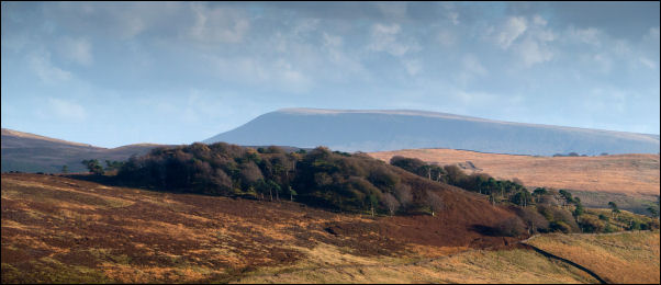
Distant View of Pendle. |
|
At a gate with a large bench mark on the gatepost the track
vanished and the path continued down across a green field to
Hareden. The buildings here are quite old and the first I saw
with a date stone lintel was W.H 1690. Apparently there used to
be a building called Hareden Hall which was pulled down in the
1940s or 50s. There wasn't anyone around to ask about it. |

Hareden Daestone 1690 |

Hareden. |

PCWW Preston Corporation
Water
Works valve box. |
|
I followed the access road down towards the Trough Road but
before the bridge turned left to follow a path by Langden Brook.
As I followed it back towards the Langden car park I passed a
solitary valve box with PCWW (Preston Corporation Water Works)
on it. I was glad I went that way as it was delightful walk in
the afternoon sunshine. |

Smelt Mill Cottages. |
|
|
|
|
|
|
|