|
Duddon Bridge, The Pike, Ulpha,
Pickthall Ground, Cumbria. |
|
|
SD 1994 8835 |
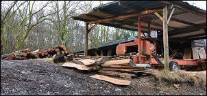 Beckfoot timber sawing |
 Bad ground in Rainsborrow Wood |
The track followed along the side of Low Park then into Middle park to emerge in to the open just before the road at Bobbin Mill Bridge. I was heading for the summit of The Pike but the map is very indistinct about the paths it shows. I entered Rainsborrow Wood where there was no indication of the way to go. The whole area was awash with drainage water coming off the fells. I found a path marker and followed it with considerable difficulty along a soggy and overgrown track. It climbed up then came to a tall fence where it ended abruptly. When I got home I checked the large scale map which does show it stopping. I can’t understand why the forestry people would point anyone into this horrible place with nothing but trees and no views. I could see that others had been diverted here and I took the only way out by climbing over the fence. |
|
That was the easy bit as the other side was a huge area of brambles. I’m lucky they’ve not started growing yet after winter as they’d be totally impenetrable. It was still difficult getting through to the next fence at Pike Woods but at least now I had a path to follow. I took a steep line up though the wood then emerged in to open ground and through a gate to the last push to the top of The Pike. The views were worth the climb. A low wall and flimsy fence ran over the summit but many people have climbed over in the past so I followed. I picked a steep grassy descent down to an old copper mine level which I’d seen from the other side of the valley while walking last week. The next part of the descent was even steeper as I crossed 2 walls to join the easy path to Baskill. A path marker tried to point me across a boggy field so I took the farm track to join the road instead. |
|
|
I descended to Ulpha where I had a look in the Church of St John the Baptist. A sign in the Church says it has been on this site since the late 1400s. I crossed Ulpha Bridge then took the left track up to Birks. Last week I’d headed north along the track through the woods. This time I headed up the rough path on to Dunnerdale Fells. The path varies quite a bit and is partly nice easy to follow on grass and sometimes across featureless boggy ground. There were nice views down in to Dunnerdale as I continued to the road at Kiln Bank Cross. Over the summit I started the descent then took the branch along the old miners track up to the right. |
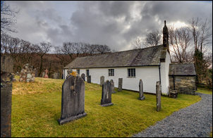 St John the Evangelist, Ulpha |
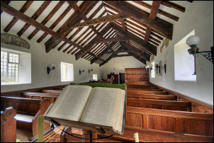 St John's interior |
I was on this path last week but soon left it. This time I followed it all the way up to the Stickle Quarry area. I stopped by the old level to look in to the mine entrance. I remember several years ago sheltering in the entrance with Eric Bell while we had our lunch. It was pouring with rain and blowing a gale at the time. The way ahead was multiple choice. I was heading roughly for Hovel Knott but many paths seemed to be available. In addition there were many scramble bike tracks running all overt the fells. I picked my way round the wet areas keeping to the west of Great Stickle then descending to a nice path near Stickle House Barn. An easy path took me to Pickthall Ground where I went through the gate to join their access road down to Croglinhurst. I stayed on the road towards Lower Bleansley but soon left it to take a track up to the right. There was a property up there which looked like a weekend retreat. |
|
A path continued through Croglinhurst Wood then steeply up to the Cuckoo Stone. I couldn’t see anything remarkable about the stone to give it its name. The path over Rawfold Bank was indistinct in places but I eventually emerged on to an easy to follow track which took me down to a gate and the main road above Rawfold. It was then an easy walk down the road to Bank End and the car. |
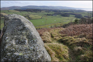 The Cuckoo Stone |
|
|
|