|
Knarsdale, Tom Smith's Stone,
Grey Nag, Whitley Castle, Cumbria |
|
|
NY 6598 4904 |
 interesting sign near the road |
|
|
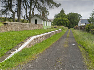
After a couple of miles I reached Slaggyford where I thankfully left the main road and turned left up a minor lane. Then there was a pleasant surprise as I came to a delightful area which is where the old railway line crosses. It was the Alston line which opened in 1852 and closed in 1976. There is an information board and the platform of the old Slaggyford Railway Station is still there. I continued up the lane to a point where I wanted to leave it and head for a track up Knarsdale. |
 Slaggiford Station in 1970 thanks to Alan Young for the photo |
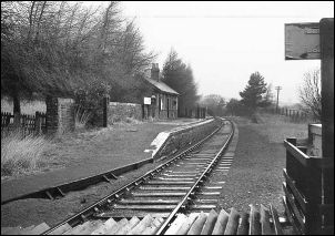 Slaggiford Station in 1970 thanks to Peter Howie for the photo |
|
When I got to the junction there was no path sign so for a while I wasn’t sure if I was on the correct route. I realised I was when I saw a Knarsdale notice board. The way ahead was a long double walled track heading for the moors. Up ahead was a man walking his dog and we chatted about the weather as I passed him. Further up a land rover came up and passed. Up the track he stopped to check one of the weasel traps. He was one of the rangers and I asked him about the jet wreckage on the tops and also Lawyer’s Cross ruins. He didn’t know anything about either of them. The end of the walled section was marked by a substantial shooting hut. Unfortunately it was locked. The track now heading up the open valley and the surface had recently been stoned. Down to my right I could see the small stone shepherd’s hut called High Shield on the map. I paid it a visit to investigate and have an early lunch. The door had fallen in but the roof was still on. |
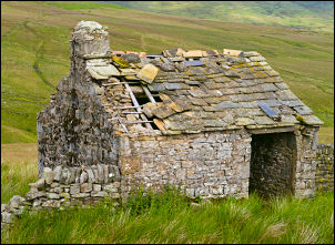 High Shield, Knardale |
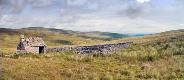 wide view of High Shield |
|
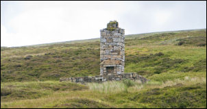 only the chimney stack remaining |
Further up the track I could see the remains of another hut to the left but this one only had the chimney stack remaining. |
|
My objective was to investigate the aircraft crash wreckage I found on 29 Jun 2011 and to do that I needed to leave Knarsdale and head up the fell side to the SW. The river banks were quite steep so I spent as much time as I could walking up alongside the river side. As I climbed the fell the sky became dark and cloudier. By the time I’d reached the summit area the rain had turned heavy. Over the top I could see the wing wreckage I’d found before and nearby were more pieces including the jet engine casing. Back on the summit by the wall was a substantial chunk of aircraft parts and the other wing. All of it sat in an impact crater. |
 crashed aircraft jet engine with my walking pole to give scale |
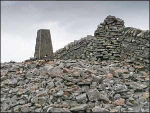 Grey Nag summit |
The rain was now worse than torrential so I left the site and headed along the fence to Tom Smith’s Stone. I then followed the fence NE towards Grey Nag where I could see the summit cairn about a mile away. The going wasn’t as bad as I was expecting and there was even a faint path for part of the way. Approaching Grey Nag there is a better view of the O.S. trig point and impressive cairn built around the wall over the summit. I headed down along the wall to the NE where there was definitely no path to follow. After crossing the deep valley of Thornhope Burn I passed an old ruin on the side of Great Heaplaw. It is odd that it is shown on the 1:50K map but not the 1:25K. There’s not much left of it so I’m surprised it’s shown at all. |
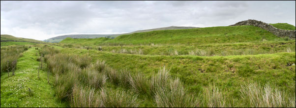 the defensive ditches around the Roman Fort |
|
|
As I descended towards the Pennine Way I saw the impressive sight of the Roman Fort of Whitley Castle which has several defensive ditches surrounding it. It is also the first one I’ve seen that isn’t rectangular. This on is diamond shaped on plan. I walked across the ditches and on to the top. After a look round I rejoined the Pennine Way and then there was just a short walk through the woods back to the car. |
|