|
Megget Head, Broad Law, Tods
Knowe, Wylies Burn, Dumfries & Galloway. |
|
|
NT 1506 2027 |
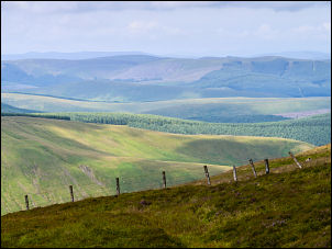 view from Cairns Law |
 Shepherds’ Cairn |
There was wet ground for just over half a mile but as I started up the steeper hill to Shepherds’ Cairn it was much better underfoot. The cairn was worth making a detour to see then I set off to find the wonderfully named Porridge Cairn. It was shown on the map as being some distance east of the fence. I headed in the right direction but then started to descend towards Score Burn but I didn’t want to lose any height. |
 NATS VOR station |
|
|
The cairn turned out to be nothing more than a low pile of stones and may have been demolished some time ago. I re-joined the fence and continued to the summit trig point at 840m (2756ft) and the very strange sight of the Radar Station in front of me. It is a (VOR), short for VHF omnidirectional radio range and is a type of radio navigation system for aircraft. The sign on the door indicates it is run by (NATS) National Air Traffic Services. Continuing over the summit area is what looks like and electricity substation and further on a radio mast. The ground continued firm underfoot as I descended towards Tods Knowe but then it started to get rough and difficult to get through. Instead of heading for Lamb Knowe I decided to descend to Wylies Burn which looked like an attractive valley below. |
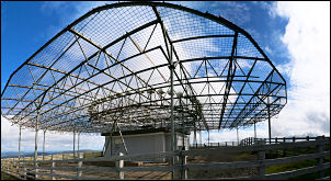 NATS VOR station |
|
I’m glad I did as the descent was easy and the valley bottom quite interesting in appearance. I crossed the river and headed up for a track that had been cut in the hillside. Once there it was an easy walk along the contour towards Meggethead. I didn’t need to go near the buildings as there was an easy grassy route to the road ahead. The road was an easy walk along Megget Water and an easy uphill walk back to the car. |
|
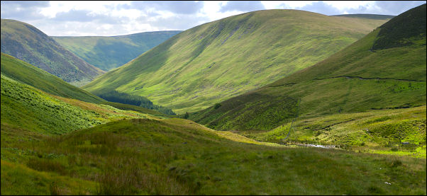 Wylies Burn |
|
|
|
|