|
Heltondale, The Pen, Loadpot
Hill, Bonscale Pike, Barton Fell, Cumbria. |
||
|
NY 4974 2145 |
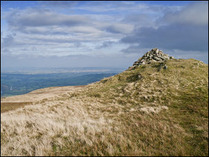
 OS trig post on Loadpot Hill |
|
 View to Hallin Fell and Ullswater |
I crossed Heltondale Beck over a nice old stone bridge but it had been spoiled by a pointless set of wooden handrails on either side. Presumably it’s to conform to health and safety but you’d have to be pretty stupid to fall off the bridge. The footpath sign pointed vaguely across the field to the right and the map seemed to show it on the far side of the wall. I couldn’t see a crossing point over the wall and the far side was wet rushes and no sign of a path. I just followed my side of the wall up the hill and joined the main path up ‘The Pen’ from there. I followed the path steadily up the ridge to a point below Hart Hill. I took the branch path to the right but with hindsight I should have carried straight on. I’d hoped to come out at the ruined hut and chimney but the path I was on took me directly to the summit of Loadpot Hill. I didn’t realise my mistake until I saw the Trig Point column appear in the distance. |
|
|
When I got to the top the weather seemed to improve a bit. Initially I followed the main path to the north but soon left it to head for the lower path to the west. This took me along to High Street, the rout of the old Roman Road. It also gave me some nice views across to Ullswater to my left. A short way on I stopped to check out the boundary stone called Lambert Lad on the map. It’s an unremarkable piece of stone and I can’t think why it’s got the name it has. I left the path and headed down into the valley to try and find the feature shown on the map called ‘Stone Circle’. I couldn’t find any sign of a circle but looking at the 1:50K and 1:25K maps it’s not surprising as each map shows it in a different place. I continued across the valley to Swarth Fell and joined a nice path heading north. The weather continued to clear and the views across Ullswater and Hallin Fell were very nice and atmospheric. One of today’s objectives is to find the feature called Bonscale Tower. |
 Bonscale Tower and Ullswater |
|
 Place Fell in the distance |
|
|
 Bales of ferns on Askham Fell |
I soon found it and it is a very substantial cairn perched on a promontory jutting out from Bonscale Pike. It gave a very commanding view across the lake and fells. I descended to Swarth Beck then joined a path on the far side which took me up to Arthur’s Pike. I then joined the main path down Barton Fell but soon left it to head across open moor to join another path taking a more direct route back to the car. It was here that I realised that one of my gloves was missing. I’d worn them most of the day as it was a chilly 6degC and with the wind made it feel cold. It had warmed up a bit recently and I’d stuffed the gloves in to my pocket. I retraced my steps back across the open moor to try and find the lost right glove but with no success. I know it’s only a glove and I can soon buy a replacement but that’s the one that had kept my hand warm on some of my highest Himalayan climbs. The path down was easy and enjoyable and eventually took my back to the road and car. On my way home I drove by Lowther village. |
|
|
||
|
|
||