|
Martindale, Steel Knotts, High
Street, Loadpot Hill, Jeanie Brewstr's Well, Cumbria |
|
|
NY 4358 1922 |
 Cote Farm from Steel End |
|
There had been very heavy rain overnight and the path to Steel End was awash. Last night I’d created a gpx track file on the PC and transferred it to my smart-phone. The intention was to help find some of the indistinct tracks across Helton Fell. I’d also hoped it would show me the path up Steel End but a fairly distinct path was visible and turned out not to be the one shown on the map. The wind was coming from the west and was a bit of a problem at times. I got to the summit ridge without problems and headed for what looked like the summit cairn. When I got there another un-cairned peak was visible to the south. It seemed higher and when I got there found that it was by checking with the GPS. The wind was now becoming a real problem and at one point I was knocked off my feet. I was thankful for the wall along Brownthwaite Crag which gave me some shelter. Near Gowk Hill I reached Fusedale Beck and stopped at the ruined building for a quick look round. |
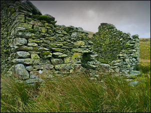 Ruin at the head of Fusedale Beck |
|
The path up to the Roman Road at High Street continued roughly SE and was easy to follow though there was a lot of evidence of the recent heavy rain. Nearing the top I tried to find some shelter to eat my sandwiched and managed to find some behind the wall just below the summit. It was still quite difficult in the wind as I headed north along High Street towards Loadpot Hill. Squally rain showers and some hail were very painful as they hit with a lot of force. Over Loadpot Hill I followed the main track to Wartches where I took and minor track to the right to look for Jeanie Brewster’s Well. There are a few tracks in the area and even though I started on the right one I found myself on the wrong part of the fell and had to cut across open ground to regain the right track. Across Helton Fell I found the well which turned out to be a spring that had a brick tank and lid built over it and was presumably being used for someone’s water supply. |
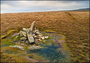 Small cairn of Wether Hill |
|
My next objective was a reservoir on Barton Fell but with no path I had to walk on a NW bearing across open ground which was rather slow in places. The site of the reservoir was not at all obvious and presumably it is underground. A hole with a cast iron pipe sticking out was the only indication. I soon joined the main path off Barton Fell and followed it down to the main track above Barton Park. There were several people about now that I was off the high fell. It was still windy but not as bad. The track is the one I used last week and this time I used it to Martindale. When I reached the buildings at Bankhouse I left the track and followed a path across a field and down to the road. I stayed on the road most of the way back to the car, only leaving it to take short cuts at the zig-zag section. There were quite a lot of cars about and there seemed to be some sort of event on as people were looking up at the fells. |
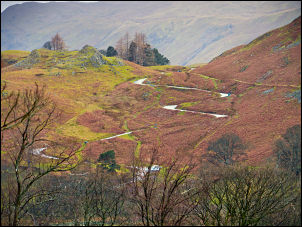 The Road to Martindale |
|
|
|