Sunday 23rd Jan 1983.
We woke to a thin cloud cover but some
stars were still winking through. Just before sunrise the clouds
at the east end of the Loch were lit by a red orange light
underneath which didn't give prospects of a good day ahead.
According to the book ‘Scottish Hill Tracks’ the next part of
our route should be above the 500ft contour but there seemed to
be a way at the loch side. After packing up we were on our way
descending to the lock and before long we picked up a trail
which being easy to follow we stayed with. Surprisingly it
improved and we couldn't believe our luck as we ambled along
taking in the views. We came to a cluster of ruined crofts, what
tales those immaculate stone walls could tell? As we left them
behind the track began to deteriorate and we were eventually
reduced to finding whatever way we could along the mountainside.
Some miles later we came on another cluster of ruins but once
again no path materialized to help us on our way. |
|
The going was fairly tough and we were glad to round the last
headland to get a full view of the end of the loch. On the south
bank we could see the house called Oban. It looked too plush to
be a bothy so I'm not sure what it's use is. The first river
running into the loch posed an interesting problem. |
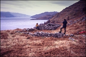
Old bothies along Loch Morar. |
As expected there was no bridge and the water was too deep to
negotiate with boots on. Nothing for it but to wade across, so
with boots and socks in hand and ice axe for support in the
other I launched myself into the cold water.
|

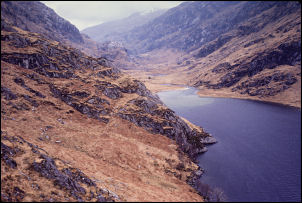
Steep north side of Loch Morar. |

Charlie at the river crossing. |
|
The feeling in my feet and ankles was more of pain than cold and
what a relief it was to reach the south bank. There was a
certain malicious pleasure in watching first Dean then Charlie
undergo the torture I'd just endured. Charlie let loose with his
mastery of highly descriptive nouns. The next headland couldn't
be traversed so we had to climb over it but on the other side we
were treated to a nice view of a small bay and the ruggedness of
Glen Pean stretching up into the distance. When we'd descended
to the flat estuary we crossed the river a little further up,
this time we didn't have to take our boots off. The track was
easy to follow but very wet in places. Glen Pean reminded me of
Glen Dessary, except that this Glen has much steeper sides and a
greater feeling of remoteness. The ascent was steady and at a
point where I reckon the summit of the pass should be I found
myself climbing rapidly to the south, way up above where I
should have been. |
I checked the map and discovered my mistake. We descended to the
pass summit and started down the other side. We soon came to a
small tarn filled with incredibly clear water and hemmed in by
almost vertical sides. We stopped for a while to look into the
depths, all the way to the bottom. A little further down an
interesting tangle of huge boulders came into view.
|
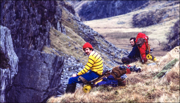
Can't remember the location. |
|
|
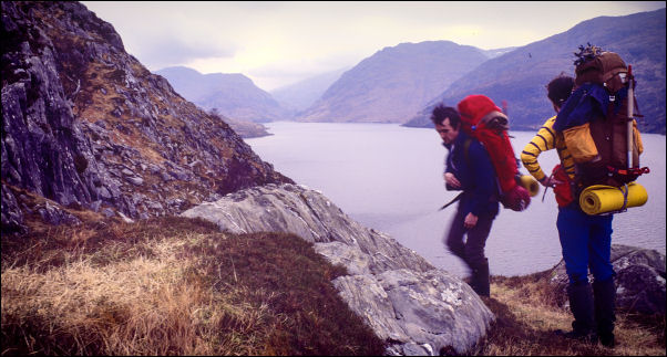
Dean & Charlie along Loch Morar. |
|

Ruined bothy |
Above the clear loch |
|
We again stopped for a while to investigate. Underneath we found
a maze of nooks, crannies and caves. Some we would have spent
the night in but our thoughts were on the Pean Bothy where we
hoped to spend the night if it was OK. We followed the south
side of the river to the next loch but the only way on was an
interesting scramble along the south Bank, not a path on the
north shore as shown on the OS map. In fact there was no
evidence of a path where the map showed one. A mile further down
we caught sight of the Bothy. It looked OK but was on the other
side of the river. Once again we waded across but by now I was
getting used to it. The Bothy we found to be in excellent
condition with one large communal room downstairs and a sleeping
level up some steps. I wasted no time in getting a brew going
then set about cooking a meal to fill everyone up in readiness
for tomorrow. Shortly after we arrived the rain started but just
at the moment it seems to have stopped (8pm). |
|
|