|
The rain continued
through the night and the wind increased considerably. I packed up a
very soggy tent and set off at 7:10am into thick mist. I followed
the wall downhill, keeping it to my right and managing to get a bit
of shelter from the wind. The path was extremely wet and I had to
make many detours out into the wilderness to get past the large
areas of standing water. Quad bikes had been this way and I was
annoyed by the way they’d used the walkers path adjacent to the wall
and ploughed it into an even deeper morass of black goo. At Tor Mere
Top I took the indistinct left path and followed it across open
ground towards the road at Tor Dike. At the road I took a short rest
in the lee of the wall, just to get some relief from the driving
rain and constant wind. A marker post pointed to a path somewhere in
the mist. I followed it diagonally up the hillside but found the
quad bikes had been before and churned it up. After a while I
decided the path was so bad I took my own line up the hill. I took
measured diagonal routes that took me up the steep west side of
Great Whernside. When the gradient eased there was still some rough
ground to cross before reaching the stone wall that follows the
ridge over the summit. The wind increased in ferocity and there was
no visibility. The wall was all I had to follow. I noticed a small
rodent trap to my left. A wooden post had been placed over a small
stream with a metal cage and snap trap over it. A difficult thing to
describe but a dead stoat hung in its jaws. The wind and rain
prevented my photographing the scene. I pressed on along the ridge
of Great Whernside to the trig point pillar. I’d originally planned
to camp somewhere in the area but the weather made that a none
starter. I could only just stand up in the wind and all I wanted to
do was press on and get out of the terrible weather. |
|
There was a very
faint hint of a path but I kept my compass handy to keep me in the
general direction. I had to swing round to the east and soon lost
any sign of a path. The terrain was featureless so I just trusted in
the compass. I found Stone Head Crag and a fence line which took me
in the right direction. The map doesn’t show any kind of a boundary
so is out of date. The fence took me too far and began to descend
into Nidderdale. I was heading for Sandy Gate so had to follow a
rough compass bearing to get me in the right direction. The going
underfoot was appalling; a mix of black wet peat and water pools all
around was very difficult to get through. I headed for the valley
bottom and a rain swollen beck below. I dropped below the mist and
could see nothing but featureless wet bog stretching into the
distance. It seemed to take forever to cross. |
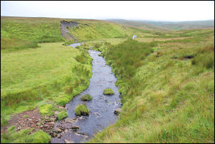
Mossdale Beck. |
|
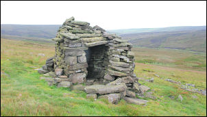
The stone shelter above Mossdale. |
Down by the river I
came across another of the rodent traps, this one was empty. On the
horizon ahead was a strange outline. I headed for it and found it
was an interesting stone shelter which was on the path I'd
originally planned to follow. |
|
Below was a substantial stone building
at the site of an old mine. I followed the path down and as I drew
closer noticed a parked landrover. Two men had been working inside
and were just leaving. The building was a shooting lodge and they
seemed to have been getting it ready for the next group of shooters.
They set off across the ford and along the track down. |

The old mine building now a shooting
lodge. |
|
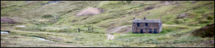
Distant view of the shooting lodge |
I kept to the left of the river and
followed a green track up above Mossdale. It was interesting looking
down to the raging river because it had vanished, presumably taking
a more complex underground route to the sea. |
|
Over the wall was a
vehicle track not shown on the map. I followed it as it was going in
the right direction. It was nice to be able to make good time and
not negotiate bog after bog. In the distance a stone chimney
appeared and this was the general area I was heading. The whole area
is abandoned lead mine workings and I stopped a bit short of the
chimney to pitch my tent on one of the few patches of grass. I
didn't want to collect water from the many springs issuing from the
spoil heaps so collected some from a peat stained river by the
track. |

Chimney and spoil heaps
at Yarnbury lead mines. |
|
|
|