All I could see was
thick mist when I unzipped the tent at first light. It always gives
a depressing start to the day. It was 8:20am when I got underway as
I was in no particular hurry to rush into the wind and mist. It had
rained during the night and so I had a soggy tent to pack away. I
followed the wall south and the mist seemed to thin a little. I came
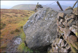
to the county stone, a huge boulder with many initials and dates
carved on it. It was also the meeting point for three stone walls
which converged on it. Before the major boundary changes of 1974 the
stone was the junction of the boundaries of Lancashire, Westmorland
and Yorkshire. It is now on the boundary of Lancashire and Cumbria.
I could now see my way ahead and below me to the left was a walled
track that would take me to the road. I followed a wall down towards
it and as I approached realised it would not be the easy walk that
I'd hoped.
The county stone.
The devastated track.
It had been ripped to
pieces by off road motorbikes. It was reduced to deep furrows that
were full of water and mud. As each scar became impassable another
was gouged out. I kept to the fell for a while then made my way
along the track edges where other walkers had tried to go.
Eventually the road surface improved as new stone had been imported
to form a passable surface. Even the motorcyclists hadn’t destroyed
it yet, but I suppose they will in time. The wind got up and the
rain started as I reached the road. I turned right and followed it
for a while before turning left through a gate and on to the wet
fell. I was following a fence which became a wall and it took me
steeply up in the direction of Whernside summit.
The wall turned left
and the path went right. There was no visibility so I just followed
the path through the lashing rain. I reached the trig point on
Whernside summit and tried to take advantage of the shelter wall and
stone seats. But they were so small that you can only sit on them if
you take your pack off. I didn't bother and crossed to the other
side of the wall and headed north along the main stoned path. It's a
pity the weather is so bad as the views from here are very good. My
objective for the day is a spring shown on the map to the north. As
I approached the wall to my left where I would leave the path a
woman approached with a yappy dog bouncing up and down on the end of
its lead. She suddenly stopped and started talking to the dog, which
continued to yap away pointlessly. As I passed I said good morning
and was completely ignored by her. It was as if I'd suddenly become
invisible and all that existed was her and her dog. I just continued
and turned left at the end of the wall. I headed west along another
wall until it came to a tee junction. I turned left and continued
till I reached the spring shown on the map. It was there and just as
I'd hoped a small spring issuing clear water straight out of the
ground. Just uphill from it I pitched my tent in a depression to get
some shelter from the wind. The rain had eased as I put the tent up
but soon it started heavy again.