|
During the night the wind dropped and
the cloud cleared. It was starry and mostly clear. The temperature
also dropped and by first light it was -1degC and the tent was
frozen. I'd brought my excellent Peak petrol stove to cook on so the
sub zero temperature was no problem at all as I boiled the pan for
my first brew. |

Moonrise from Ingleborough. |
|
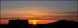
Sunrise above Ingleborough. |
Sunrise from Ingleborough |
|
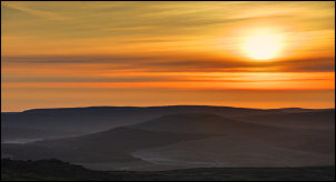
The Howgills from Ingleborough |
There wasn't a breath of wind as I
wandered about the Ingleborough plateau waiting for the sunrise just
before 6am. I wandered through the old hut circles then had a look
at the few remaining stones of the old sanatorium before watching
the thin crescent moon above Pen-Y-Gent and the sun rise into a low
band of cloud. I enjoyed a leisurely breakfast and packed the tent
away to be on my way about 8am. It was so nice I wandered round the
summit again before setting off down on the path at the NE corner. |
|
I was heading for Chapel-le-Dale but
firstly wanted to check out the spring below Swine Tail. It produces
much more water than the one just above the steep descent to
Humphrey Bottom. The path is quite steep and not normally a problem
but I needed to take my time with full pack. The clear sky at
sunrise had started to haze over. After the steep descent I was on
an easier and level path which gave nice views of my next objective
ahead; Whernside. Limestone outcrops and small trees began to appear
and as I descended to the ruined outbuildings of Souther Scales.
There was no sign of occupation but it was being used as curtains
were in the windows and washing up stuff in the kitchen. A direct
path took me to the main road and across to the side road to
Chapel-le-Dale. I followed it a short way to the church of St
Leonard's then turner right up a narrow lane. |
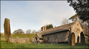
St Leonard's, Chapel-le-Dale |
|

the statue |
Further up I came to one of those
unexpected things that make a particular route worthwhile. A
metallic statue was by the track that had been removed and thrown
down Hurtle Pot nearby and subsequently recovered from 30ft of water
by divers and re-erected. How fantastic is that? |
|
 |
|
THE STATUE
For years a Statue stood on this spot. It was vandalised on Saturday
August 27th 1983 and subsequently found in 30 feet of water at the
bottom of HURTLE POT. An enthusiastic team of divers made the
recovery and it has been erected again as found. It was the creation
of the late Charles L'Anson the well known Sculptor and Artist. Time
will tell if the spirit of the 'BOGGARD' of HURTLE POT is now
enshrined in the Statue. |
|
I continued up towards Ellerbeck and
had good views back to Ingleborough. The weather was still high
cloud but it looked like I would miss any rain today. I was on a
stoned farm track and followed it to Bruntscar and the building
called Brunscat Hall (sic). The 'T' having been lost between the
Ordnace Survey map and the building name plate. The path then headed
up the fell towards the summit of Whernside. It was a steady plod
but not too bad. I was now seeing a few people out walking as I
reached the summit. I crossed over the wall and stopped briefly in
the wind shelter to check my map before cutting off NNW to head down
to the spring by the wall and my camp for the night. |

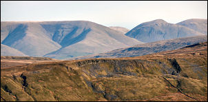
Ingleborough from Ellerbeck. |
|
|