|
The 6am bus to Preston was bang on
time (£3.45) single. As I arrived at the Railway station just before
6:40 I noticed the 6:40 train to Glasgow was just about to leave. I
quickly bought a paper and jumped on. It would take me to Carlisle a
bit sooner than I’d planned but my motto is if I can get nearer
sooner go for it. In Carlisle I read the rest of my paper in the
waiting room until it was time to catch the 8:40 to Barrow. It was a
cool sunny morning as we left and the train arrived in St Bees on
time at 10am. My plan is to do the first part of Wainwright’s Coast
to Coast walk. I did the whole walk in May 1980 with Charlie and I’m
just curious how things have changed. |
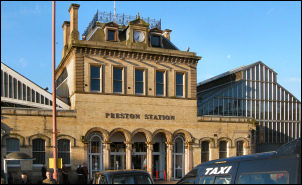
Preston railway station |
|

St Bees railway station. |
Things had changed
a lot. I got off the train with many other walkers, some about to
set off on the same walk. In 1990 we didn’t see another coast to
coaster until day 5. I stopped to take a picture of the level
crossing which showed the St Bees name. A woman walker rushed up to
me and asked if I wanted her to take a picture of me on my camera
with me in it. I politely declined. It was blue sky and sunny as I
set off but not particularly warm. I reached the car park and sea
wall and was horrified at the number of people heading out along the
cliff top path. I headed off and pretended they weren’t there and
just enjoyed the sunshine and clear views across to the Isle of Man
and across the Solway Forth to Scotland. |
|
It wasn’t all
picturesque and a lot of the northern horizon was infected with wind
turbines. The ultimate blot on the landscape. I tried to keep a
positive view but it was difficult as most of the gates were the
ludicrous kissing gates that are only designed for thin people.
Anyone wearing a large ruck sack (me) can’t get through. I had to
climb the wooden fence on each occasion. Madness! Someone has been
paid to design these gates. Apart from the gates the path was easy
to follow and I continued north until I passed the lighthouse where
the path swings east. Approaching the old quarry I met a couple of
locals who pointed me in the right direction. |
|
The quarry was
being used again and the path had been diverted slightly. At the
quarry bungalow I turned inland along the access track. I followed
it and enjoyed the easy walking all the way to Sandwith where I
found a seat and treated myself to a 2 minute rest before continuing
along the road north. It’s quite a nice hamlet but at the north end
is a pub which was closed. I cane to Lanehead and crossed the road
to follow an old track which is now a mostly overgrown path
festooned with undergrowth and nettles. The path improved to a track
as I approached the buildings of Demesne. I crossed St Bees Rd to
Bell House where the original Wainwright route had been diverted.
The diversion took me down through fields to an underpass of the
railway line and back to Stanley Pond. My view is that the diversion
makes sense. The path climbed through fields and under an old
disused railway line until I reached the empty Scalegill Hall
buildings and the main road into Whitehaven. |
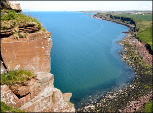
From St Bees Head |
|

2007 Coast to Coast statue
by Colin Telfer. |
I stopped briefly by a statue that had
been erected to commemorate the coast to coast walkers. It was nice
enough but the shrubbery around it was neglected. I followed the
road into Moor Row which I found fairly depressing and lifeless. I
continued past old empty and boarded up buildings until a sign took
me across fields and across the same old rail track which was now a
path and cycleway. I left it to follow a path that was being cleared
by a Council worker until I came to the Cleator cricket ground which
I’d commented on in my 1980 diary. There was a cricket match on then
but now just a few people practicing. I reached the main street in
Cleator and turned left. There was no welcoming bench to sit on.
Before leaving there was a small shop where I’d hoped I could buy
some water. I walked in to see two women attendants having a
conversation and totally ignoring my presence. |
|
Fawlty Towers must
have been inspired by this shop. I left and continued along paths to
the long climb of Dent fell. There were a few people in front of me
when I reached the buildings of Black How. I set off up the forestry
track and briefly spoke to a couple in front. Climbing though the
conifers I caught up to a group of about 8 walkers as we arrived at
the main cairn on Dent Fell. They stopped and I didn’t. As I passed
them there was a waft of bad body odour, not mine. Another similar
summit with a smaller cairn followed. Then there was a descent
towards Nannycatch Gate which became ridiculously steep at the end.
In the valley there was an easy path along the river until the road
at Scarney Brow. A sign could be of use here as there is a branch in
the track and no indication which way to go. The right, and minor
branch, goes to the false stone circle and the main left branch goes
to the main Scarny Brow road to Ennerdale Bridge. So I missed the
delights of the stone circle and finished up descending the road
into Ennerdale Bridge. It’s quite a nice village and as I set off
along the road to Ennerdale Water I saw a man with a yellow jacket,
clipboard and several children taking a cycling proficiency test.
The sight was so rural and delightful. I can’t see it happening in
the main urban sprawl, well not on the main roads. Ahead of me I
could see Anglers Crag, above Ennerdale Water. I’d originally
planned to camp there but as I’d camped there before I knew water
was a problem. I reached the bank of Ennerdale Water and found a
stream issuing from a nearby spring. My phone even had a signal so I
decided to camp just above the waters edge. |