|
Thankfully the
fierce winds of last night had died down by morning. I looked out of
the tent to a clear starry sky. The radio weather forecast was
incredibly vague and didn’t give me much of an idea what to expect.
When bankers get thing wrong and people suffer because of t they are
rightly vilified. When weather forecasters get it wrong it is taken
as normal and nothing is done. Last Monday morning I remember
distinctly that they said Friday would probably be clear and cold.
As I write this it loos like it will be cold wet and windy. I hope
I’m wrong and they were right. |
|
The clear sky soon changed to
overcast. The ice on the tent was now water and a lot got wrapped up
with it as I packed my stuff away. I set off and continued up the
river bank to have a look at the higher valley where I’d originally
planned to camp. It was very exposed and would have been too
dangerous in yesterday’s winds. It looked interesting and may
qualify for another visit. I turned left ad followed the contour as
I headed round towards Long Comb. Sheep trails made the going much
easier than the map would suggest. I reached the side of the Comb
and descended to the large sheepfold. The walls had long since
collapsed but the flat bottom had been well engineered as it was cut
into the hill on one end and the excavated material used to fill up
the other, thereby creating level ground. An old track was opposite
so I followed it up to join the main track up towards Sail. The
saddle at the top doesn’t have a name on the map and I find this
puzzling as it is of some significance. |
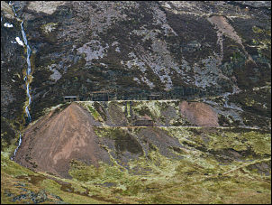
Old High Force mine above Pudding Beck |
|
It was calm when I packed the
tent away but now the wind was back with the same force as
yesterday. It was difficult standing on the pass summit so I didn’t
hang around and started my descent towards Ard Crags opposite. That
was my next objective but I had to descend to the valley bottom
first. The path descends diagonally to the right but heads further
down the valley. Part way down I turned off to the left and followed
a minor branch to the saddle of the pass. There is no obvious path
up to Ard Crags so I took my own diagonal line up to the right to
join the summit ridge. It was very unpleasant in the fierce wind and
the earlier rain had now turned to hail. Low cloud prevented any
views which would have been good in clear weather. Up ahead the snow
covered summit of Robinson was in cloud. I’d hoped to get over there
today but the deteriorating weather was making that look less
likely. The total length of the ridge to Newlands Hause wasn’t far
on the map but it seemed to take ages. Eventually the Road over the
pass appeared below me and I carefully negotiated the wet grassy
descent. |
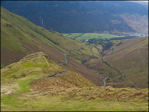
Descending to Newlands Hause with
Buttermere in the distance |
|
Nearing the road I noticed a cyclist
through the gloom. He’d stopped to add another layer of clothing
before continuing down towards Newlands Valley. Directly across was
the raging torrent of Moss Force crashing down from the higher
Buttermere Moss. To the right was the path up to its summit which I
followed to the top of the rise. The wind and hail were getting
worse and it would have been dangerous to try and get any higher.
The weather made the decision for me and I began to look for some
shelter to pitch my tent. |
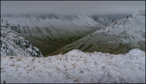
Knott Rigg from Moss Force |
|
To my left I saw a few sheep taking
shelter behind a mound. There was enough flat ground to get the tent
up so I decided to pitch there as sheep usually know best when it
comes to shelter. As I approached they moved on to the next mound
that provided shelter. The ground was excellent and all the pegs
went in easily. With a quick trip down to the beck to fill my water
bag I was back at the tent. I was just in time. As soon as I got in
the tent a snow storm hit with incredible force. Snow was battering
the tent, sticking to the side, then sliding down as it accumulated.
For the rest of the day and through the night the tent was battered
with a mix of snow and rain. The tent was definitely the best and
safest place to be. |
|
|