Heading for Scotland with my bike and set off at 5:30 a.m. to ride
to Preston Railway Station. It was light enough to ride without
lights and shortly after setting off I could see the sun rising. The
6:40 a.m. train at Preston was on time and I put my bike in the
relevant compartments where two other bikes were already hanging
from the roof hooks. The first part of the ride was a clear sunny
morning but shortly after Carlisle the weather became overcast and
rain started. When I reached Glasgow the worst of the rain had
passed and it was just overcast without rain.
Outside Glasgow Central Rail Station
I left Glasgow Central Railway Station and cycled north to the
Buchannan Street Bus Station to have a look at the Time Sculpture
which is an interesting feature of steel legs with a clock on top,
presumably representing the march of time. I continued along the
roads for a short while before I was able to leave and follow the
cycle track to the start of the Glasgow Spur of the Forth & Clyde
Canal. The southern end of the canal is called Port Dundas and must
have been an amazing sight when it was in full use.
Running out of time
Substation by the canal
Port Dundas
Across the water is Speirs Wharf where many barges are still moored.
My original plan was to leave the canal for a short distance to
visit the workshop of the artist Andy Scott. I only found out a
couple of days ago that he is now working in Philadelphia and his
workshop is no longer used by him. As I cycled along the towpath I
could see the building he’d previously used and the front doors were
shut and it looks like another company working there. I find the
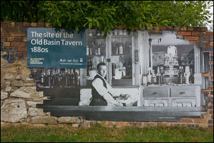
information boards along the canal extremely interesting and it was
good to reach the one marking the spot where the Old Basin Tavern
was located.
Old Basin Tavern
Some of the walls of the building remain but the bulk of it is gone.
I found the large 1880s photograph on the wall showing the original
bar a fascinating way to take us back to those times. Further on was
another interesting board showing information about the Glasgow
Rubber Works which were used for war production in World War II and
afterwards they recommenced making tennis balls for the Empire.
Old buildings by the canal
Approaching the main Clyde and Forth canal a local cyclists caught
up and we rode for a short while and chatted. He was heading west
and when I came to the point where I was to turn east I said goodbye
and left the towpath for a short while to drop down to the road
where I passed under the canal then back up onto the Falkirk length.
The weather continued overcast but thankfully the rain held off. I
stopped briefly by a pub which had a fascinating information board
displaying information about the adjacent nature reserve and also
about the meteorite the Apostle high meteorite which landed in 1804.
A fragment is on display in the Hunterian Museum in Glasgow. A
photograph of it is shown on the board.
I continued along the towpath to Kirkintilloch where I stopped
briefly where the route crosses the road. There is a stone nameplate
on the bridge saying Forth and Clyde Canal. I re-joined the towpath
briefly but I knew there was a turn off to the left that I needed to
find. The signpost is there but it is a narrow gap between hedges
and drops down to start the railway leg out to Lennoxtown. The first
part is a long a rutted street then across a road to pick up the
cycle track running along the old railway route.
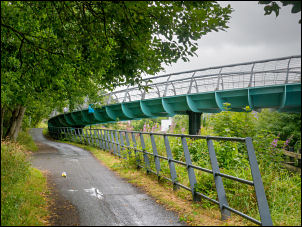
Approaching Kirkintillock
I have cycled along this line previously and it is an interesting
ride but rather dull in today's overcast and cloudy weather. However
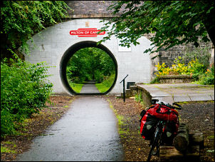
the main highlight was just up ahead as I reached the bridge at
Milton of Campsie which is also the site of an old railway station.
The bridge has an interesting modification presumably to strengthen
it and provide a circular tunnel through for walkers and cyclists.
Milton of Campsie
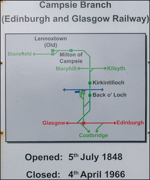
An information board states that the railway opened in 1846 and
close in 1966. I continued under the bridge and on to Lennoxtown
where I left it to turn right and join the road. After turning right
onto the road I came to a junction where I turn left onto Milton
Road A891 and into Lennoxtown centre. I stopped at the Co-op to buy
to buy 2L bottles of water at 49 pence each. The rain had returned
as I continued to turn right onto the B822 that would take me to the
Campsie Fells. It was a steady climb at first and it was interesting
to see a sign on the left for a bike fitting shop.
Opened 5th July 1848 closed 4th Apr 1966
The climb up to Campsie Glen was a good road and a steady gradient
so wasn't a problem other than the rain. As I reach the car park at
the summit I was just under the cloud base and had very little View.
The online map calls it ‘car park in the sky’. I’d planned to camp
nearby and a green path heads up to the east which is where most
people seem to walk from the car park. I started to push my bike up
and was hoping to camp up to the left on a promontory with a flat
area. Unfortunately I would have had to cross an area of deep grass
and rushes which were soaking wet with the rain.
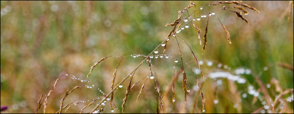
A wet Campsie Glen camp
Wet view from the tent
As a poor second choice I found a flat area right by the path.
It was still deep grass but I didn't have far to walk into it. The
main downside was that after pitching the tent there were several
people walking up and down the path most making comments outside the
tent. Unfortunately I am too near to the car park and several
motorists kept parking up with loud blaring music on their radios. I
also seem to be on the flight path for Glasgow Airport.