Last night's rain had stopped but it was still thick cloud where I
was camped. The grass was also covered in water droplets so I had to
cover my shoes with plastic bags as I packed the tent away. I was
packed by 7 a.m. and wheeled the bike down to the road and continued
into the Campsie Fells on the B822. Last night I'd mistakenly
thought that my camp was at the high point of the pass but as I
continued riding the road continued upwards for almost two miles
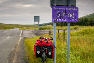
before I reached the summit. I stopped by a boundary sign which said
welcome to the District of Stirling Scotland's Heart.
Stirling Scotland's Heart
The mist had cleared but I was still under an overcast sky. I
started my descent and soon came to two houses under construction.
Being such a remote spot I wondered why anyone would want to build
here. It was a long and steady descent down into the valley heading
towards Fintry. Before I reached it I turned right on a minor road
heading towards the Carron Valley. The road was narrow but
thankfully very quiet and only a few vehicles passed the whole time
I was on it. It undulated up and down but nothing too severe. I
reached the west end Dam of the Carron Valley Reservoir and shortly
afterwards turned left onto a minor road I'd visited a couple of
months ago while in the car. I was climbing steadily upwards, though
nothing too steep. I came to a group of houses at Easter Cringate.
This seemed to be the summit and generally I was descending easily
to the next river at Earls Burn. There was a nice stone bridge at
the river crossing and I stopped briefly to have a look at a
waterfall upstream. Just as a check I switched my phone on and was
surprised to get a full signal and 4G data. A steady climb followed
which became quite steep near the summit but not for long. I then
started the long descent all the way down to a reservoir called
North Third Reservoir. The Descent continued and quite steep in
places until I came to the river Bannock Burn. As I climbed out of
the small valley I wasn't concentrating and continued my descent
down Polmaise Road but soon realise my mistake as I had missed my
turn off. It was annoying because I had to climb back up the road to
take the correct lane. It was a steady descent down to the bridge
over the M9 motorway which I crossed over then headed through a
housing estate and onto the A87 to where I turned right and headed
south to the main Bannockburn Visitors centre.
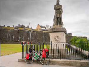
I cycled up to the main monuments which gives some information on
the Battle of Bannockburn on the 24th of June 1314 when the Scots
King Robert the Bruce defeated the army of Edward II King of
England. I was fortunate as I continued because the statue of Robert
the Bruce was there without anyone around. Shortly after taking some
photos the whole area was swamped with tourists. I returned to the
main centre where I had a quick look inside and was appalled to see
so much rubbish and tat on sale to the tourists.
Arriving at the Bannockburn battle monument
Robert the Bruce Battle of Bannockburn on the 24th of June 1314
when the Scots King Robert the Bruce defeated the army of Edward II
King of England.
Visitor Centre full of tat
I returned to the main road and headed north to retrace my earlier
ride and continued in to Stirling town. I kept going until I reached
the narrow road heading up to Stirling Castle. It was extremely busy
with tourist’s vehicles and large coaches heading up to the main car
park. It is a steep cobbled climb and I had to keep riding off the
road and onto the pavement to let the large coaches pass.
In Stirling the Rob Roy statue has lost
his sword
Another Robert the Bruce at Stirling Castle
Stirling Railway Station
At the top the car park was almost full and this is as far as I went
as access to the castle has he paid for. I had a quick look at
another statue of Robert the Bruce then left the car park to descend
through Stirling by another route. I rode to the railway station and
had a quick look inside before heading north again for a short while
then turning right over a bridge that crossed the railway lines. The
road headed east and I came to a footbridge which is on the cycle
route that I was following to Cambuskenneth.
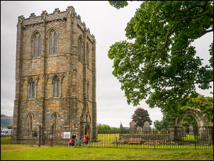
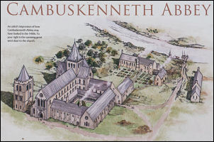
Cambuskenneth Abbey
Cambuskenneth
Abbey
Old entrance
The cycle route turns left but I turn right to have a look at the
remains of Cambuskenneth Abbey which was founded in 1147. It was
quite an interesting area to visit and doesn't seem particularly
popular with tourists. I had the whole place to myself and at the
far end of the ruins is the burial place of James III. An
information board says that after the Battle of Bannockburn this is
where the first Independent Scottish Parliament began. I returned to
the cycle track and follow the road north which gave a good view of
the Wallace Monument on the Hill. I turned right onto the A907 which
was quite busy but not much of a problem as I rode along to head
east. I continued along the road for a few miles until I left it to
dip under a bridge and south along a cycle track on the old railway
route.
I was heading into Cambus and the distillery where I was able to see
large piles of barrels on the left. They were behind a large steel
fence but I managed to get a few photos. The cycle track continued
all the way to Alloa where I left it to join the road for a while
and negotiate the centre of the Town area. At the railway railway
station I cycled across the car park and down to the ASDA car park
where I went inside to buy some chocolate doughnuts for my lunch. I
returned past the railway station and joined a cycle path which
headed north east to leave the town.
Cambus barrels
It continued out into the countryside and thankfully I was able to
ride without going onto the main A908 road. Apparently it hadn’t
been surfaced that long and it follows the line of the old railway
through Tillicoultry and on to the town of Dollar. I wasn't sure
where to camp for the night and I thought there may be a grassy area
by the cycle track but it was too narrow so I continued on to Walton
Crescent and into the town where I called at the Co-op shop to buy
water. I returned to Devon Road and south on the B913 until I came
to the bridge over the River Devon. I'd previously checked the map
and seen a footpath along the south bank of the river and decided to
wheel my bike along to see if there was any where suitable to camp.
The path was fairly narrow and not suitable for riding but wheeling
the bike wasn't a problem. I came to a Weir on the River where a few
people were congregating and chatting.
I continued past it and fortunately found a good spot where I could
pitch the tent. I propped my bike against a tree and began to put
the tent up. A few people walked by and it was nice to chat as
people seem to have time to stop for a while. One man was heading
east with his dog and we chatted for a while and he seemed
interested in my bike ride. His name was Paul and he had his
sidekick with him called Joey who is a Jack Russell dog.