|
I’d previously noted a possible camp
pitch on the west side of Little Dun Fell in the Cumbrian Pennines
so decided to give it a try and escape from the Christmas run up for
a couple of days. I’m in a bah humbug mood so roughing it on a
hillside made sense. I had a clear drive along the M6 motorway and
reached the small car park at Kirkland about 10am. It was deserted
when I arrived but another car soon arrived and a walker emerged,
fitted his gaiters and set off up the fell. I heaved my pack out of
the car, strapped my tent to the top and set off down the lane and
along the farm access towards Ranbeck Farm. |
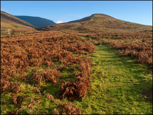
Looking up to Grumply Hill.
The sunshine would soon vanish. |
|
There was high cloud on the hills but
lower down I was in cold sunshine. The house at Wythwaite had a
couple of cars parked outside and the ruins of the adjacent original
farm buildings were lit by low sunlight. The path that leaves the
far goes through a gate where the gate latch is inaccessible to
anyone not wearing wellingtons. The mud and water were too deep for
walking boots so I had to climb the gate. I wasn’t looking forward
to the left turn up towards the fell because it’s always been
terribly wet on previous occasions. Although there had been lots of
rain over previous days the walk wasn’t as bad as I’d expected. Once
through the final gate, which was accessible and not flooded, I was
on an open sunny fell. Ahead I could see the track to the left of
Grumply Hill and in the far distance the same path going diagonally
up Wildboar Scar and into the cloud. |
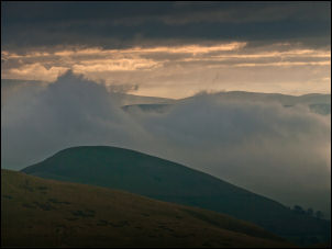
Gathering clouds over Burney Hill |
|
I was heading for the site of a long
abandoned and derelict reservoir high on the west side of Little Dun
Fell. I could have followed the path to Crowdundle Head and taken a
fairly direct route but I’d seen an old mine level on the map and
decided to investigate that by taking a different route. After a
steady plod up Wildboar Scar I reached flatter but much rougher
ground. The path runs between boulders and now there were snowfields
to make the going much harder. The snow wasn’t hard enough to walk
over meaning that most steps would break through and I’d have to
laboriously climb out for the next step. |
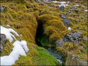
The old mine by Crowdundle Beck |
|
Having a full pack on with supplies
for a couple of days didn’t help. I left the path at around 650m to
follow the contour to the right. This should have taken me directly
to the mine but there were many snowfields in the way which needed a
lot of detours. When I got to the area I was too high and found
myself standing on the top of a cliff with the river far below. I
could see the eroded spoil heap from the mine just above the river
so managed to find a way round to descend a steep grassy slope. The
mine entrance was almost grassed over completely but a huge amount
of water was flowing out and forming a series of waterfalls down to
the river below. |
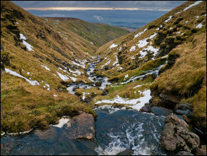
Crowdundle Beck |
|
This site would definitely justify a
return visit in dry weather to see if the water quantity continues.
Below the level is a waterfall in the main river and I had to climb
upstream to be able to get across. A steep climb up a grassy bank on
the far side took me up on to the open fell side. I was in mist so
had no distant feature to aim for. The ground was the same mix of
boulders and tussocky grass with intermittent snowfields. By heading
slightly uphill I was able to reach my destination and recognised
the old reservoir embankment when it appeared through the mist. It
had now got very windy and I tried to find some shelter but there
was none. The only water supply was the reservoir outlet which now
meandered trough bog. The pitch I chose for my tent was exposed to
the wind but the ground was good to get all the pegs in to make as
secure a pitch. After putting the tent up and getting water it was a
case of battening down the hatches. |

Camp on Little Dun Fell |
|
|